Page 2 of 10
SR 88 - Apache Trail
Posted: Oct 21 2010 6:52 am
by AZLOT69
Wikipedia wrote:The Apache Trail in Arizona was a stagecoach trail that ran through the Superstition Mountains. It was named the Apache Trail after the Apache Indians who originally used this trail to move through the Superstition Mountains.
The current Apache Trail links Apache Junction (33.4152°N 111.5807°W) at the edge of the Greater Phoenix area with Theodore Roosevelt Lake (33.6725°N 111.1531°W), through the Superstition Mountains and the Tonto National Forest.
Today, the majority of Apache Trail remains unpaved, turning into a dirt road a few miles up from Tortilla Flat, and continuing as such for nearly the full remainder of its length. The section east of Apache Junction is known officially as State Route 88. It is also the main traffic corridor through Apache Junction, turning into Main Street as the road passes into Mesa, and regains the Apache name by becoming Apache Boulevard in Tempe, ending at Mill Avenue. Prior to the completion of the Superstition Freeway in 1992, the Apache Junction portion of the Apache Trail was part of US Highway 60, which was rerouted to the Superstition Freeway once it was completed.
The Trail winds steeply through 40 miles (64 km) of rugged desert mountains, past deep reservoir lakes like Canyon Lake and Apache Lake. The narrow, winding road is unpaved from just east of the town of Tortilla Flat to Roosevelt Dam; there are steep cliff drops and little in the way of safety barriers. The trail requires caution when driving and it is not recommended for large RVs, SUVs, or caravans. Some large RV rental companies in the US do not allow their vehicles to be taken on this route.
The Apache Trail will be closed for some major road repairs from November 15 - January 21, 2011. major delays will occur prior to and after those stated dates. Plan your outings accordingly.
See press release:
http://www.azdot.gov/highways/projects/ ... 101510.pdf
Re: Apache Trail SR88 Road Closure
Posted: Jan 22 2017 12:46 pm
by cactuscat
@SuperstitionGuy
I always noticed evidence of that "drill in and split" method on large boulders along Grand Canyon trails ... cool.
Re: Apache Trail SR88 Road Closure
Posted: Jan 22 2017 1:05 pm
by garyc57
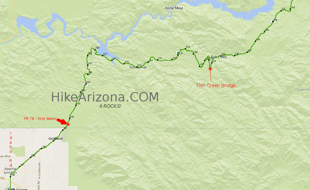
lindaagm wrote:near milepost 226
According to AZMapper from ADEQ, milepost 226 is at:
Latitude: 33.5375352 (33° 32' 15.1269" N)
Longitude: -111.2784571 (111° 16' 42.4454" W )
Elevation: 2377 feet (724.5 meters)
Thanks, Victor!
Gary
Re: Apache Trail SR88 Road Closure
Posted: Jan 22 2017 2:46 pm
by The_Eagle
Looks to be just SSW of Bronco Butte.
Photo via ADOT Facebook
https://hikearizona.com/dex2/igallery/i ... hp?id=5227
Re: Apache Trail SR88 Road Closure
Posted: Jan 22 2017 5:17 pm
by big_load
@The_Eagle
That's a big rock.
Re: Apache Trail SR88 Road Closure
Posted: Jan 22 2017 7:02 pm
by SuperstitionGuy
Near the bottom of Fish Creek shortly before the bridge. The concrete on the right side guides water down to a small culvert that takes it underneath the road and on down to Fish Creek. This is just before the larger walk through concrete culvert.
7;30 PM Sunday - ADOT says the Apache Trail is open all the way to Lake Roosevelt.
Re: Apache Trail SR88 Road Closure
Posted: Jan 22 2017 8:49 pm
by Nighthiker
I guess the boulder is a bit much for a fulcrum and a lever, would be like lugging a stone for the Pharaoh.
Re: Apache Trail SR88 Road Closure
Posted: Jan 23 2017 12:27 pm
by cw50must
So I never check things like this a head of time and it just so happens I headed out there yesterday and it for sure is closed right at tortilla flat. I went over to the guy who was stationed at the roadblock, I thought it was for the water at the creek, to assure him I could cross the water safely, but that's when he said it was closed for the boulder not the water crossing.
Re: Apache Trail SR88 Road Closure
Posted: Jan 23 2017 4:06 pm
by SuperstitionGuy
cw50must wrote:but that's when he said it was closed for the boulder not the water crossing.
I just checked their website again and it still says:
---the Apache Trail is open all the way to Lake Roosevelt.
Maybe they do not think boulders are a problem?
Re: Apache Trail SR88 Road Closure
Posted: Jan 23 2017 4:13 pm
by LindaAnn
@SuperstitionGuy I think it was reopened last night.
Re: Apache Trail SR88 Road Closure
Posted: Jan 23 2017 9:27 pm
by big_load
lindaagm wrote:@SuperstitionGuy I think it was reopened last night.
Did they say whether they found a flat coyote under the boulder? Did he stretch back out like an unfolding accordion and pop back into three dimensions when it was removed?
Re: Apache Trail SR88 Road Closure
Posted: Jan 30 2017 3:59 pm
by mr_squishy
The road closure must have been for boulder removal - the road was open at Tortilla Flat when I was there last Tuesday hiking to Geronimo Head.
Re: Apache Trail SR88 Road Closure
Posted: Jan 31 2017 8:15 am
by chumley
News article with an update on the boulder. I think the road is open again.
http://www.pinalcentral.com/casa_grande ... 9f645.html
Re: Apache Trail SR88 Road Closure
Posted: Jan 31 2017 11:09 am
by SuperstitionGuy
chumley wrote:News article with an update on the boulder. I think the road is open again.
Are we to assume they used LNT principals and just moved it back into place?
Re: Apache Trail SR88 Road Closure
Posted: Feb 01 2017 6:33 pm
by SuperstitionGuy
February 1, 2017 The Apache Trail (SR88) from the end of the asphalt to beyond Fish Creek Hill has been graded and is in excellent shape. The El Coyote rock is also absent and unaccounted for.
SR 88 - Apache Trail
Posted: Aug 21 2017 4:15 pm
by hikeaz
Apache Trail repairs/delays/closures....
The Arizona Department of Transportation is preparing to make emergency repairs to State Route 88 (Apache Trail) in the wake of damage caused by severe flooding in July. The highway was damaged in several locations between mileposts 196 and 220 (map link below) following heavy rain.
The affected stretch of SR 88 between Apache Junction and Canyon Lake is
open, but motorists should drive with care and watch for traffic cones next to storm-damaged areas along the highway.
Emergency work is
scheduled to begin in mid-August and last approximately two months. For information about traffic restrictions, click the Traffic Alerts tab on this web page.
https://www.azdot.gov/projects/central- ... fic-alerts
The safety improvement and pavement preservation project already planned on SR 88 between mileposts 203 and 220 will begin
after the emergency repairs are made.
Map link >>
https://www.azdot.gov/docs/default-sour ... f?sfvrsn=2
Re: Apache Trail repairs/delays/closures....
Posted: Aug 21 2017 4:54 pm
by joebartels
area
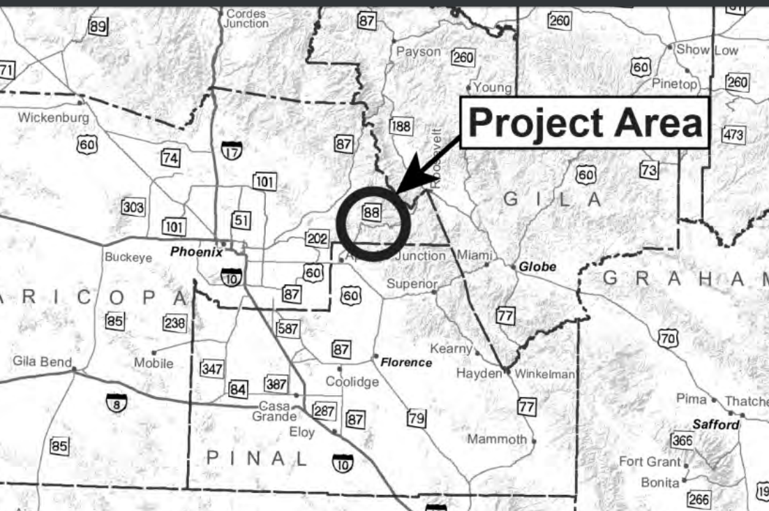
mile markers
Re: Apache Trail repairs/delays/closures....
Posted: Aug 21 2017 5:02 pm
by hikeaz
Many thanks for the map posts, Joe.
On another note... glad your health is improving.. keep it up!

Re: Apache Trail repairs/delays/closures....
Posted: Aug 21 2017 8:53 pm
by big_load
That's a pretty long stretch. I hope it's all done by Thanksgiving.
Re: Apache Trail repairs/delays/closures....
Posted: Aug 22 2017 6:33 am
by AZLumberjack
big_load wrote:That's a pretty long stretch. I hope it's all done by Thanksgiving.
ADOT.... Need I say more?
Re: Apache Trail repairs/delays/closures....
Posted: Aug 22 2017 9:50 pm
by nonot
website says it will take 1 year