Page 1 of 1

West Fork

Posted: Dec 03 2005 10:04 am
by kylemorgan
I've been told that there is a hike from Williams to Sedona. Any truth to that? Someone told me it was west fork but I don't know...

Posted: Dec 03 2005 3:43 pm
by joebartels
There's some truth to it. You can do it and West Fork could be part of your route. Though, I'm not aware of a popular commonly mentioned route. Nevertheless, sounds ten times better then the poorly routed AZT that's commonly known.

Posted: Dec 04 2005 2:33 pm
by mttgilbert
joe bartels wrote:sounds ten times better then the poorly routed AZT that's commonly known.

Amen!

Re: West Fork

Posted: Dec 05 2005 2:43 pm
by hikeaz
kylemorgan wrote:I've been told that there is a hike from Williams to Sedona. Any truth to that? Someone told me it was west fork but I don't know...
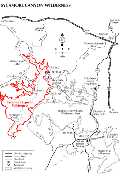
You can hike/swim the West Fork of Oak Creek from Woody Mountain Road (FR 231 - SW of Flag) down to Sedona - it is a long day hike (14 +/- miles) with multiple (cold) swims Image- no trail in the upper section, but good trail for the last 5+/- miles. Image

Printable WEST FORK (USFS "doom and gloom") fact? sheet here > http://www.fs.fed.us/r3/coconino/recrea ... aution.pdf


A trip that sounds closer to what you refer is Sycamore Canyon.
There are various ways to access the upper canyon.
The most direct is likely to take FR 56 to its southern terminus and bushwhack your way down there.
You may also access the upper end of this hike (no trail in upper 1/3) from about 35 8.047 N x 112 1.805 W - that is due north of White Horse Lake.
Or, if you drive SE from WHL to about 35 6.363 N x 111 59.147 W you can work your way down there, as well.
Given 3-4 days you can walk all the way to Parson's Spring Trailhead, near Cottonwood or exit at the Dogie T/H off FR 525 (C?) southwest of Sedona. (Dogie T/H would shave a day +/- off of the hike - but you may incur the Red Rock Pass extortion fees Image at this trailhead)

Take a Sycamore Canyon map if you go - available here > http://www.fs.fed.us/r3/coconino/maps/index.shtml

Spring is ideal for this as to ensure adequate agua. After May it can pretty scarce in places.

Image