Rim Lake Vista Trail #622 skirts FR 300 and the Mogollon Rim from start to finish. It is an easy hike with great views just a few feet from the rim's edge. Since we were camping at the Mogollon Campground, we hiked the trail from west to east, starting at the Mogollon Trailhead and ending at the Rim Top trailhead.
Our hike started on a paved path that led from the campground to the second of three vistas with parking, which might serve as trailheads for those wishing to hike a shorter section of the trail. Along the path leading to Vista Lookout, the first vista, were several great vantage points that made for great pictures. We proceeded on the paved path for a little less than a mile from Vista Lookout to Woods Canyon Vista. This is where the paved path ends a few hundred feet down the trail. This is also the junction with the Meadow Trail #505 which leads to Woods Canyon Lake.
We again followed the Rim Lake Vista Trail for not quite a mile to Military Sinkhole Vista. This vista also serves as a trailhead to Sinkhole Trail #179. At 3.4 miles into the hike, we then reached the trail junction to the Rim Campground. Here, a sign indicates it's a half-mile north to the Rim Campground or 0.8 miles to the Rim Top Trailhead. The last section of the trail follows an old jeep trail for part of the time until you arrive at the FR 300 crossing. Once you are across the road, the trailhead is just a short distance.
There is also a short section of the trail from the Rim Top Trailhead further south-east to Hwy 260 if you wish to extend your trip from 4.2 miles to near 5 miles. We didn't have anybody waiting for us at the Rim Top Trailhead, so we just followed the path back, which made for a nice 8.4-mile day hike full of incredible views all along the way.
When hiking several trails on a single "hike", log it with a generic name that describes the hike. Then link the trails traveled, check out the example.
WARNING! Hiking and outdoor related sports can be dangerous. Be responsible and prepare for the trip. Study the area you are entering and plan accordingly. Dress for the current and unexpected weather changes. Take plenty of water. Never go alone. Make an itinerary with your plan(s), route(s), destination(s) and expected return time. Give your itinerary to trusted family and/or friends.
Permit $$
None
Directions
Road
Paved - Car Okay
To hike Rim Lakes Vista Trail #622 has two main trailheads. The Rim Top Trailhead near the east end of the trail is located off Forest Road 300, about a half-mile from its junction with Hwy 260, which is immediately across from the Mogollon Rim Visitor Center. The Mogollon trailhead is located at the Mogollon Campground in the Apache-Sitgreaves National Forest, which is about four miles up FR300 from the Mogollon Rim Visitor Center, according to a map I obtained there.
 Route Editor

 Rim Lake Vista Trail #622 skirts FR 300 and the Mogollon Rim from start to finish. It is an easy hike with great views just a few feet from the rim's edge. Since we were camping at the Mogollon Campground, we hiked the trail from west to east, starting at the Mogollon Trailhead and ending at the Rim Top trailhead.
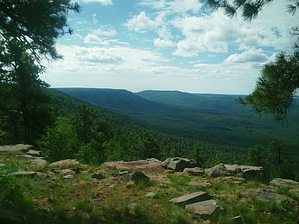


