Route Editor

| Guide | ♦ | 8 Triplogs | 0 Topics |
details | drive | no permit | forecast | 🔥 route |
stats |
photos | triplogs | topics | location |
| 11 | 8 | 0 |
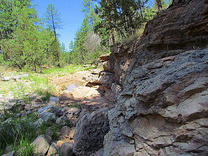
Peppered in lichen by WilliamnWendi  In the mood for pine tree forests and a grassy meadow? How about an easy hike that has an off-trail flair for cutting your teeth on. The destination for this hike is a three-tiered 30' waterfall that is peppered in lichen. It's seasonal but even dry, it makes for a fun excursion that is a relatively safe place to practice some route-finding skills, and there is a very good chance that you might see some Elk. Given the many signs, I would say they frequent this area. I saw one myself, the antlers least. In the mood for pine tree forests and a grassy meadow? How about an easy hike that has an off-trail flair for cutting your teeth on. The destination for this hike is a three-tiered 30' waterfall that is peppered in lichen. It's seasonal but even dry, it makes for a fun excursion that is a relatively safe place to practice some route-finding skills, and there is a very good chance that you might see some Elk. Given the many signs, I would say they frequent this area. I saw one myself, the antlers least.The TH is a gate in the fence line 40ft. south of the sparse parking area. Once through the gate, scratch your head, turn around once or twice, and then forget about finding any trace of the trail here. Just make your way downhill through the pines, and once in the meadow, just keep walking the short distance to a ravine that is maybe thirty feet from the treeline. Take a moment to mark your location, so you don't miss it coming back.
To get there and to get to the main falls area, follow this ravine westward. From the rock wall, you can see a marshy area, and the best way to get around that is on the north. A little bit west of the wall, there is a small footpath that appears and disappears almost as quickly. After the trail ends, return to the creek and continues following that. Shortly the first of three barbed wire fences block the way. The top wire is covered with PVC pipe in sections, I am guessing to make it safer for the Elk to cross, but it also makes it easy for us bipeds. The second fence is a tight squeeze next to a tree. The third fence is as easy as stepping over it. You may notice some jeep trails on your way. Nature has reclaimed some; some are still in use. Some are shortcuts, and some will take you off on perhaps some other misadventures. Don't lose your bearings on the creek, and if you use the jeep trails, most of them parallel the creek but one heads due south; avoid that one. Also, keep in mind that some of the surrounding area could be private land. The dark brown rock of the falls stands in contrast to any of the surrounding features and is peppered in lichen. Enjoy the hike and keep your eyes and ears peeled for Elk. Gate Policy: If a gate is closed upon arrival, leave it closed after you go through. If it is open, leave it open. Leaving a closed gate open may put cattle in danger. Closing an open gate may cut them off from water. Please be respectful, leave gates as found. The exception is signage on the gate directing you otherwise. Check out the Official Route and Triplogs. Leave No Trace and +Add a Triplog after your hike to support this local community. | |||||||||||||||||||||||||||||||||||||||||||||||||||||||||||||||||||||||||||||||||||||||||||||||||||||||||||||||||||||||||||||||||||||||||||||||||||||||||||||||||||||||||||||||