Canyons are inherently risky. Flash floods occur without notice on sunny days. Technical skills & surrounding topography knowledge required yet does not eliminate risk. |
|
tap row or icons for details
|
| Distance One Way |
|
3 miles |
| Trailhead Elevation |
|
4,609 feet |
| Elevation Gain |
|
350 feet |
| Kokopelli Seeds |
|
4.17 |
| Interest Off-Trail Hiking, Seasonal Waterfall & Seasonal Creek | | unreported if dogs are allowed
editedit > ops > dogs to adjust |
| | |
|
|
4 |
2022-05-01 | AZLOT69 |
|
|
15 |
2015-09-30 | AZLOT69 |
|
| |
|
| |
|
|
Historical Weather |
| Trailhead Forecast | | |
|
 |
|
|
| Preferred May, Jun, Sep, Oct |
|
|
| | |
Named Locations Coordinate Links
| |
|
| help future canyoneers |
| post a gps route now |
| | |
| |
|
|
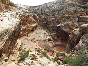
 White Canyon stretches and drains territory for about fifty miles to the east of Lake Powell. This hike description covers three of the best miles of spectacular non technical canyoneering ending at the Black Hole, a dangerous slot section only the highly experienced should attempt. When you reach standing water turn around.
|
 Route Editor