Route Editor

| Guide | ♦ | 8 Triplogs | 1 Topic |
details | drive | no permit | forecast | 🔥 route |
stats |
photos | triplogs | topic | location |
| 8 | 8 | 1 |
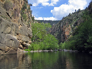
Canyons are inherently risky. Flash floods occur without notice on sunny days. Technical skills & surrounding topography knowledge required yet does not eliminate risk.
Very tough no trail canyon by itsradBrad  Notice NoticeTime will vary considerably by your ability. Foreword This hike can range from difficult to impossible depending on how well prepared your group is and the amount/type of gear you carry. Canyon Overview We began the hike off 142E east of Bear Canyon and ended at Bull Pen road, where we dropped off a vehicle before heading off to the trailhead (16 miles west as the crow flies).
Consider You must be prepared for long days of overcoming obstacles, backtracking, constant wading, and water crossings, and approximately 10 swims for this trip. Some of these swims are 100+ yards long, and the water is very cold in April when we went. We estimate water temp in the high 40's low 50's (April). Author's Gearlist To tackle these swims, we utilized a small inflatable raft for floating 2 packs at a time and a rope to ensure we didn't lose it. The swims are very challenging and the biggest time suck of the entire trip. I would recommend practicing changing shoes/prepping your raft so that you can minimize this time suck. Some days you will only make 5 or some miles of progress in 8 hours of hiking. Here is the gear list that I used: Shelter, Tent, Sleeping bag, Poncho and a hiking pole is an absolute MUST! Food/Cooking: Food, Cookware, Burner, Lighter, Fire Steel, Plate, Spork, Cup, Baggies/Bags, Water Bladder, Water Filter, Bottle, Fishing rig, Stringer, Net, Seasoning Hiking Gear: Pack, Boots, Aqua shoes, Drybags, Sunglasses, Extra reg glasses, Monocular, Flashlight, Headlamp, Whistle, Insect Repellent, Sunscreen, Compass, GPS, Gloves, Cell Phone, Camera, Rope, Walking pole, Raft Tools: Multi-tool, Brush, Hatchet, Shovel, Knife (2) First Aid: H2O2, Hydrocort UNG, AAA Ung, Epi-pen, Cipro, Flagyl, Ibuprofen, Gauze, Wrap, Nail Clippers, Tums, Imodium, Ankle Brace Hygiene Toothbrush, Bar Soap, Toilet paper, Deodorant, Hand Towel Clothes: Pant/Shorts, Hoodie, Thermals, 2 Shirts, Extra Socks, Flip Flops, Hat MISC: Cards, Pen and Paper, Handgun. RENT a satellite phone online before you take this trip. You will find it to be absolutely invaluable. Take this piece of advice even if you don't think it's necessary. I would recommend buying a quality pair of water shoes for this trip, no Walmart specials, or you'll regret it. Also, consider bringing a wetsuit depending on your cold tolerance. The fishing isn't too good until the last few miles, so I'd probably ditch the fishing gear and bring a net for crawfish if you want. A good GPS and 24k topo maps will save your butt when trying to keep on the right trail on your way out of the canyon on the final 6-mile stretch. Terrain The terrain in this canyon is some of the most challenging I have ever seen. When I say there is no trail, there is ABSOLUTELY NO TRAIL for the 1st 18 miles of the hike. Be ready for slow-moving. Observations The things we came across are as follows: Gravel bottomed stream (easy) Medium & large rock bottomed stream (algae = very slippery) Thick bushwhacking (sticker bushes were the worst) Short grass, dirt (a nice break from the madness) Large and medium boulders (up and overall stinking day!) Steep grades with loose dirt and rocks/cacti (very dangerous) Camping Be aware that areas suitable for camping are few and far between. If you see a spot within the last 2 hours or so of daylight, TAKE IT! Look for rock stacks as a hint of campsites above! Warning This hike is not for the faint of heart or the inexperienced. Be prepared and be safe; it's damn near impossible to get out of this canyon without finishing the hike. Good luck and be safe! This trip is a challenge, not a leisure hike. Check out the Official Route and Triplogs. Leave No Trace and +Add a Triplog after your canyon trip to support this local community. | ||||||||||||||||||||||||||||||||||||||||||||||||||||||||||||||||||||||||||||||||||||||||||||||||||||||||||||||||||||