Route Editor

| Guide | ♦ | 35 Triplogs | 3 Topics |
details | drive | no permit | forecast | map |
stats |
photos | triplogs | topics | location |
| 284 | 35 | 3 |
Canyons are inherently risky. Flash floods occur without notice on sunny days. Technical skills & surrounding topography knowledge required yet does not eliminate risk.
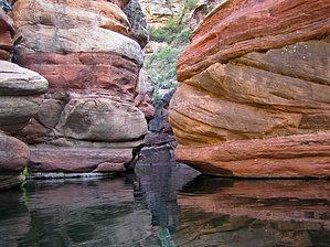
Canyoneering trip by Lizard  Overview OverviewThis is a tough but gorgeous 2-4 day hike/float/swim trip through a red rock canyon along the Mollogon Rim. Wet Beaver Canyon was the first canyoneering trip I ever took, as well as the first hike I ever posted to HAZ. Even all these years later, the hike still holds a special spot in my mind. Wet Beaver Canyon offers superb scenery, isolation, and adventure in one of the wildest and most beautiful canyons along the Mollogon Rim. Inspired by AZ-Outdoorsman's marvelous recent photo set, I've decided to re-write the 2001-11-26 description I originally posted for this hike, to correct some factual errors and to provide more information on the canyon.
From the Bell trailhead, you will want to follow the Bell trail for approximately 1 mile to its junction with the Apache Maid trail. Turn left, or north, onto the Apache Maid trail, and follow it as it climbs relentlessly up to the top of the Mollogon Rim. At the top of the rim, a sign warns that the trail is difficult to follow from that point forward. Your goal from this point is the head of Waldroup Canyon. The easiest way to reach it is to strike out cross-country, following jeep roads as they fade in and out, aiming for the northwestern shoulder of Hog Hill. A short climb over the shoulder of this small peak will deliver you to the basin where Waldroup Canyon starts to cut into the earth (this is also the starting point for the shuttle trip). Next, you will head down Waldroup Canyon. In order to make it through this canyon, you will have to descend seven waterfalls ranging in height from 10 to 30 feet. All of these can be scrambled down, or bypassed, without the need for technical rock climbing skills. The only difficult one is the fourth waterfall, which can be bypassed by a tricky scramble on creek left. If you are unsure of your abilities on rock, it may be helpful to pack a rope to lower your pack down the waterfalls, thus improving your balance for scrambling. Just downstream of the confluence with Wet Beaver Canyon, you will find powerful springs feeding the flow in Wet Beaver. The springs also create the first big pool you must swim. This pool is always much colder than the pools downstream, so don't worry if you find yourself gasping at the temperature. From this point on, it's a simple matter of following the creekbed all the way down to Bell Crossing, and the Bell trail. To make your way through the canyon, you must swim a minimum of 12 pools, and wade twice that. You will be in water the rest of the way down the canyon. There are some areas that are so beautiful they deserve to be discovered on their own, so I am purposefully leaving this description somewhat vague. The upper parts of the canyon are long stretches of aggressive rock-hopping down a thick riparian corridor, broken up intermittently by a swim across a short pool. As you cross the halfway point though, the long riparian corridors shorten, and the pools get bigger and better. My favorite part of the canyon is the lower third when it starts to cut through the red Supai sandstone. Shortly after you pass the long pool that stretches around several corners, with red Supai walls curving overhead, keep your eyes on the right (north) wall of the canyon. You should be able to spot a small cliff dwelling reposing on the wall of the canyon before too long. When you start to spot trash and other hikers along the creek, you are getting close to the end at Bell Crossing. Look for trails heading away from the creek on the right. From here, it's a simple 4-mile hike on the Bell trail back to the trailhead. Check out the Triplogs. Leave No Trace and +Add a Triplog after your canyon trip to support this local community. | ||||||||||||||||||||||||||||||||||||||||||||||||||||||||||||||||||||||||||||||||||||||||||||||||||||||||||||