Route Editor

| Guide | ♦ | 6 Triplogs | 1 Topic |
details | drive | permit | forecast | map |
stats |
photos | triplogs | topic | location |
| 50 | 6 | 1 |
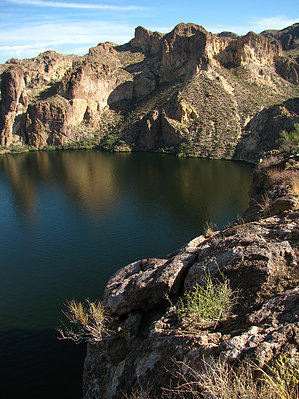
Surf & Turf II by ssk44  Overview OverviewPoint Campground Overlook is a sweet little off-trail hike that makes a great lunch destination. The overlook is perched on an overhanging cliff edge that is approximately 250 feet above the water below. Access to the designated trailhead is by boat or, in my case, kayak. The trip from the boat ramp involves a short 1.75-mile paddle to the first cove on the right just after the narrow channel that heads out from the bay near the dam. On the south side of the cove is a lovely area for pulling out kayaks onto a grassy bench just above the waterline. However, boats will need to tie up out on the gravel point to the northwest. Hike Although this is an off-trail route, the hike is relatively easy with minimal cat claw to fight with, manageable loose rubble rock, and only moderate incline. I prefer to hike along the slope that follows the south side of the drainage heading up from the lake. If you keep your eyes open, there is a faint trail working its way along the slope. While climbing up from the lake, you will see a large pronounced butte that you will keep to your left. About halfway up the hill, you will see two routes heading up to the skyline with a small butte between the two. Take the high skyline route that heads to the right. The low route will work, but it is less direct and involves scrambling up a boulder pile. After you have made your way through the high skyline pass, you will come out onto a small open mesa. Head east/northeast down a hill along the left side of a rock bluff to the cliff overlook above "Point Campground". You will know you're at the correct spot because it's the highest point along the edge and has a long flat bench across the top. The cliff has a significant overhang at one part that protrudes out far enough to hide boats that are sitting below you. This location is very severe and must be treated with respect. See maps for further clarification.
This is a beautiful spot to relax and soak in the views. It's a great afternoon hike that is not often visited. Combining kayaking and hiking on lakes like Canyon and Apache must be experienced to understand how special it is. Kayaking has a way of cleansing the soul. Being able to combo up a rewarding off-trail hike is the icing on the cake. The possibilities are endless...
Check out the Triplogs. Leave No Trace and +Add a Triplog after your hike to support this local community. | ||||||||||||||||||||||||||||||||||||||||||||||||||||||||||||||||||||||||||||||||||||