username
X
password
register
for free!
help


El Recortado - Route #1, AZ

Guide 1 Triplog  0 Topics
  3 of 5  
Fav
Wish
0
details
drive
permit
forecast
map
stats
photos
triplog
topics
location
3 1 0
Canyons are inherently risky. Flash floods occur without notice on sunny days. Technical skills & surrounding topography knowledge required yet does not eliminate risk.
Canyoneering
Consensus
View 1
Grade1
WaterA
Risk
TimeI
Statistics
tap row or icons for details
Distance One Way 1 mile
Trailhead Elevation 1,676 feet
Elevation Gain 380 feet
Kokopelli Seeds 2.27
 Interest Off-Trail Hiking, Seasonal Waterfall, Seasonal Creek & Peak
feature photo
Photos Viewed All MineFollowing
3  2009-02-21 ssk44
Author
author avatar Guides 16,843
Routes 17,472
Photos 24
Trips 1 map ( 6 miles )
Age 28 Male Gender
Location HAZ, TrailDEX
Historical Weather
Trailhead Forecast
Expand Map
Preferred Feb, Mar, Apr, May
Sun  6:02am - 6:47pm
0 Route
 
0 Alternative


remove free decal offer

 
Guide Needed
Publish Full Detail Guide


Use +Add above to share photos and triplogs
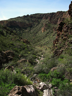
Overview: El Recortado is a wild and seldom visited area in the hills above Canyon Lake. Route #1 is an unnamed canyon ending at a rugged 100-foot seasonal waterfall (+/-). Warning: This hike involves heavy cat-claw along the canyon bottom.


  • guide related image guide related image
    guide related


Check out the Triplog.
Leave No Trace and +Add a Triplog after your canyon trip to support this local community.
WARNING! Hiking and outdoor related sports can be dangerous. Be responsible and prepare for the trip. Study the area you are entering and plan accordingly. Dress for the current and unexpected weather changes. Take plenty of water. Never go alone. Make an itinerary with your plan(s), route(s), destination(s) and expected return time. Give your itinerary to trusted family and/or friends.

 Permit $$
Information is listed below


 Directions
or
 Road
Paved - Car Okay

To canyon trip
From Mesa take Highway 88 (Apache Trail) to Canyon Lake. Purchase a Tonto Pass before heading out to the lake. With kayaks, put in at either the picnic area or the main boat ramp. Paddle approximately 2.2 miles up-lake to the designated trailhead (TH Lat. 33 degrees/33'/41.83"/N & Long. 111 degrees/25'/28.44"/W). There is no shore access at this trailhead. Boats must be tied off and left to float.
page created by ssk44 on Mar 03 2010 8:50 am
 90+° 8am - 6pm kills
helpcorrectionissue

end of page marker