username
X
password
register
for free!
help


El Recortado - Route #2, AZ

Guide 1 Triplog  0 Topics
  5 of 5  
Fav
Wish
3
details
drive
permit
forecast
map
stats
photos
triplog
topics
location
22 1 0
Canyons are inherently risky. Flash floods occur without notice on sunny days. Technical skills & surrounding topography knowledge required yet does not eliminate risk.
Statistics
tap row or icons for details
Distance One Way 1.9 miles
Trailhead Elevation 1,662 feet
Elevation Gain 745 feet
Accumulated Gain 745 feet
Kokopelli Seeds 4.38
 Interest Off-Trail Hiking, Seasonal Waterfall, Seasonal Creek & Peak
feature photo
Photos Viewed All MineFollowing
22  2010-03-06 ssk44
Author
author avatar Guides 16,843
Routes 17,472
Photos 24
Trips 1 map ( 6 miles )
Age 28 Male Gender
Location HAZ, TrailDEX
Historical Weather
Trailhead Forecast
Expand Map
Preferred Feb, Mar, Apr, May
Sun  6:02am - 6:47pm
0 Route
 
0 Alternative


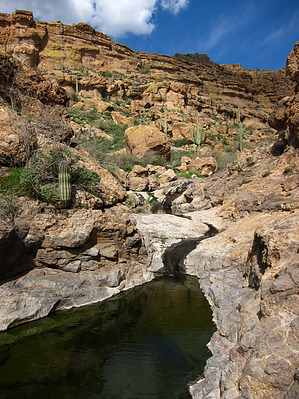
Big Gnarly Oozer
by HAZ_Hikebot

 
El Recortado is a wild and seldom visited area in the hills above Canyon Lake. Route #2 follows an unnamed canyon through a stunning hidden basin and ends at a high overlook above Canyon Lake. An exceptional destination. Catclaw is light to moderate. See maps for route description.


A gatekeeper waterfall situated about 150 feet above the shore of Canyon Lake protects the initial canyon. Access is a bypass from the west.
remove free decal offer
Cliffs surround the basin with elevated shelves on both sides of the canyon bottom. Carefully hike along the elevated shelves or follow the creek. Every thirty yards reveals something cool to explore. The final is a killer overlook situated high above Canyon Lake with epic views of the surrounding area.

2019-02-18 HAZ_Hikebot
  • guide related image guide related image
    guide related


Check out the Triplog.
Leave No Trace and +Add a Triplog after your canyon trip to support this local community.
WARNING! Hiking and outdoor related sports can be dangerous. Be responsible and prepare for the trip. Study the area you are entering and plan accordingly. Dress for the current and unexpected weather changes. Take plenty of water. Never go alone. Make an itinerary with your plan(s), route(s), destination(s) and expected return time. Give your itinerary to trusted family and/or friends.

 Permit $$
Information is listed below


 Directions
or
 Road
Paved - Car Okay

To canyon trip
From Mesa, take Highway 88 (Apache Trail) to Canyon Lake. Purchase a Tonto Pass before heading out to the lake. With kayaks, put in at either the picnic area or the main boat ramp. Paddle approximately 2.3 miles up-lake to the designated trailhead (TH Lat. 33 degrees/33'/36.89"/N & Long. 111 degrees/25'/03.12"/W). Shoreline access is good, however not suitable for powerboats.
page created by ssk44 on Mar 06 2010 10:02 pm
 90+° 8am - 6pm kills
helpcorrectionissue

end of page marker