Route Editor

| Guide | ♦ | 323 Triplogs | 6 Topics |
details | drive | no permit | forecast | 🔥 route |
stats |
photos | triplogs | topics | location |
| 2.3k | 323 | 6 |
Fairly Easy by Greg Jackson   Hackberry Springs Loop is just an extension of the Garden Valley Loop. The trailhead starts at the First Water Trailhead just past Lost Dutchman State Park on SR88. Hackberry Springs Loop is just an extension of the Garden Valley Loop. The trailhead starts at the First Water Trailhead just past Lost Dutchman State Park on SR88.From the trailhead follow First Water Trail to the first intersection then head north on Second Water (also called Garden Valley) for around a mile. When you get to the signpost for the Black Mesa Trail you will notice a pile of rocks behind the trail marker. This is the site of an old Indian ruin. If you look closely there are still small bits and pieces of pottery. At this intersection instead of heading east on the Black Mesa trail go west on a well-used single-track trail through a valley of Cholla. This is Garden Valley. Travel through to the small saddle ahead.
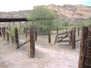
After about three-quarters of a mile, there will be a fork in the trail. To the south will be a crude gate, sometimes open, sometimes not. In the background would be views of the corrugated roof of the First Water Ranch. This, to me, is the way to complete the Garden Valley loop. The other trail leads to Hackberry Springs. After what seemed like a short mile you descend into the shadow of what seems like a two-hundred-foot cliff. Easily findable is a pipe protruding from this precipice. Of course, flowing from this pipe is the spring. I don't know how tasty the water is, but my hound lived through the experience. It is amazing to me how easily the desert can change. On the other side of this mountain are jumping chollas and mesquites, and here are grasses growing in the wet soil amidst lush green shade trees. The way home is to continue south through the narrow cliffs and meet back up with First Water Creek. The creek takes you to First Water Ranch. At the ranch just climb the well-traveled hill to the small saddle (turn around and look at the view of Four Peaks) and you will see the horse trailer parking lot where the pay station is. Follow the road, to your car. My topo software showed this to be a five-and-a-half-mile journey. Gate Policy: If a gate is closed upon arrival, leave it closed after you go through. If it is open, leave it open. Leaving a closed gate open may put cattle in danger. Closing an open gate may cut them off from water. Please be respectful, leave gates as found. The exception is signage on the gate directing you otherwise. Check out the Official Route and Triplogs. Leave No Trace and +Add a Triplog after your hike to support this local community. | ||||||||||||||||||||||||||||||||||||||||||||||||||||||||||||||||||||||||||||||||||||||||||||||||||||||||||||||||||||||||||||||||||||||||||||||||||||||||||||||||||||||||||||||||||||||||||||||||||||||||