Post Hike | Route | Photos | Triplog
Welcome to Hike Arizona
Welcome to HAZ!
Username
Password
Stay on Help     
  White Tanks Radio Summit, AZPrint: Full / Basic / Profile
Jump to Directions
Elevation Profile Weather Forecast
Statistics
 Difficulty: 3     Route Finding: 1 
 Distance Round Trip 7.6 miles
 Trailhead Elevation 1537 feet
 Elevation Gain 2389 feet
 Accumulated Gain 2400 feet
 Avg Time Round Trip 4 hours
Interest: Peak
Author TerrySwicegood
 Descriptions: 4
 Routes: 0
 Photos: 39
 Trips: 4 map  (35 Miles)
 Age: 65     Gender:
 Location: Litchfield Park, AZ
HAZ Member Photos
 Photos         Date Member
25  04-10-2010  nobert15
5  11-21-2009  desert-booni
5  05-05-2009  asu9165
4  03-21-2008  hhwolf14
26  03-11-2007  nobert15
7  03-15-2006  Vaporman
5  05-17-2005  TerrySwicego
Photosets Rated Viewed
TrailDEX     TrailDEX Map
White Tanks Map
Rate Hike Mile Ft 
 Bajada Trail - White Tan 0.95 180 
 Black Rock Long Loop 1.3 120 
 Black Rock Short Loop 0.5 68 
 Ford Canyon Trail 7.4 1,410 
 Goat Camp / Mesquite Loo 12.7 1,738 
 Goat Camp Trail 6.3 1,732 
 Ironwood Trail - White T 0
 Mesquite Trail - White T 4 1,394 
 Mesquite Willow Loop - W 8.2 1,350 
 Mule Deer Trail 3.3
 South Trail - White Tank 0
 Waddell Trail 1 40 
 Waterfall Trail 2 170 
 White Tanks Radio Summit 7.6 2,389 
 Willow Canyon - White Ta 1.7
 
 Phoenix NW
Backpack - Possible - Not Popular
Seasons - ALL
GPS Routes
 Default Route by davis2001r6 4.8 mi
 2010-03-05 davis2001r6 0.82 mi
Linked Routes
 Goat Camp to Radio Summit - White Tanks
 2010-03-27 coanbru
Expand Map
Street
Terrain
Topo
View All Routes
w/ Borders!
Jump to Hike Map
Nearby
Hikes Springs
Direct Air Miles Away to Trailhead
 Barry Goldwater Peak via Goat Camp TH
 Goat Camp / Mesquite Loop
 Goat Camp Trail
0.3  South Trail - White Tanks
0.5  Bajada Trail - White Tanks
[ View More! ]       [ View Springs! ]


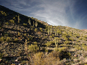
Goat alternative
by TerrySwicegood

The White Tank Range, located 35 miles west of downtown Phoenix, is part of the Maricopa County Park system. A series of well-maintained trails crisscross the park. The hike to the summit of the White Tank Range utilizes the Goat Camp Trail.

Hike: At the Goat Camp Trail Head (elevation 1537') the trail climbs steadily for 2.96 miles. At 2.96 miles (3141') the trail comes to a saddle with a faint trail heading left (west-ward). The Goat Camp Trail continues on straight toward Mesquite Canyon. Take the left turn here and hike another .83 miles (800' elevation gain) to the microwave towers on the summit. Note: As you approach the saddle where the summit trail turns right, there is a giant fallen saguaro cactus on your right. The GPS registered the elevation at the summit as 3926 feet.

Another good visual landmark for the intersection of the summit trail is your clear view of the summit microwave and radio towers off to your left as you climb toward the saddle. You will see the distinct ridge which you must climb to reach the summit.

My time climbing up was two hours and fifteen minutes at a slow, but steady pace. The round-trip is about four hours.

The views from the summit are magnificent and include the Superstitions to the east, the Bradshaws to the north, the Estrellas to the south and east, and the Kofas to the west. In mid-May, 2005 when I did the hike I was greeted by a bevy of lady-bugs on the summit.

I have done this hike every season of the year. It can even be done in the summer if you start around 6 a.m. The temperatures on May 20 were 78 degrees at 7 a.m. and 97 degrees when I returned to the car at 11 a.m.

This hike is fairly strenuous, but more rewarding to me than other hikes in the valley because one is always greeted by the solitude of the Sonoran Desert and one rarely sees other hikers.
- May 25 2005 TerrySwicegood
Preferred Months  Nov, Feb, Mar & Apr
Wish List
Water/Source:  NoneLogin Required
Preferred Start Time:  7 AM Cell Phone Signal:  High Points Sunrise 5:41am Sunset 7:32pm
Road/Vehicle: Paved - Car Okay
Fees/Permit:
AZ State & Regional Parks - $6 per car or $2 per person hiking into the park
Login for Mapped Driving Directions

Directions to Goat Camp Trailhead: Take the I-10 west out of Phoenix to the 101 Loop Freeway. Go north on the 101 to Olive Blvd. Take a left and head west 13.5 miles to the White Tanks park entrance. Continue into the park on White Tank Mountain Road. Passing the information center at about 1.2 miles. Continue on to Waterfall Road. Pass the Waterfall Trailhead. Pass the playground. Pass the Mesquite / Waddell Trailhead. Be on the lookout for a small parking area for the Waddell Trail to your left. If you come back out to White Tank Mountain Road you need to backtrack.

doug h adds: With the growth in the west valley a faster way to get to the White Tanks Park from down town (PHX) is to stay on I-10 to Cotton Lane. Then go North 7 miles to Olive Ave., there is a stop sign and a Fertazone plant on the NW corner. Take a left (west) to the park. By going this you miss the new stop lights and the added stop signs on Olive. This is only a sugestion, I know the parks department has you going out Olive from the 101 loop.

From PHX (I-10 & AZ-51) 36.8 mi - about 50 mins
From TUC (Jct 1-10 & Grant) 144 mi - about 2 hours 20 mins
From FLG (Jct I-17 & I-40) 153 mi - about 2 hours 29 mins

[Update Directions]     [Update Permit]

WARNING! Hiking and outdoor related sports can be dangerous. Be responsible and prepare for the trip. Study the area you are entering and plan accordingly. Dress for the current and unexpected weather changes. Take plenty of water. Never go alone. Make an itinerary with your plan(s), route(s), destination(s) and expected return time. Give your itinerary to trusted family and/or friends.
Login to browse without Ads
BTW, it's is free too...

 • Created for AZ, expanded from Canada to Mexico
 • Find or share your love for great adventures
 • Member driven, powered by enthusiasm
 • No oaths, good morals, real fun
 • Every hike is better on HAZ
 • Pollution free since 1996
About        Books       Extra        FAQ        Corrections Corrections       Glossary        Search        © 2010 HAZ
National Trails
Trailheads Arizona Trail  Segments
Trailheads Colorado Trail  Segments
Continental Divide Trail 
Trailheads Grand Enchantment Trail  Segments
John Muir Trail 
Trailheads Pacific Crest Trail  Segments
Trailheads Tahoe Rim Trail  Segments

Vote daily for the Arizona Trail to secure
a $50,000 grant to help complete the trail
  Events  →  View Calendar  →  Add Event
 • 2010-08-01 [ 1, 0, 0 ] Spur Cross-Cottonwood Loop Sunday Aug. 1
 • 2010-08-15 [ 2, 4, 0 ] Pine Canyon Sunday August 15
 • 2010-08-21 [ 1, 2, 1 ] Powers Garden August 21-22
 • 2010-09-05 [ 1, 1, 0 ] Donahue/Webber/Highline Loop - Sunday Sept. 5
 • 2010-11-25 [ 1, 3, 0 ] Canyonlands Fall extravaganza
 • 2011-04-02 [ 4, 10, 5 ] 2011 Rainbow Bridge Spectacular