username
X
password
register
for free!
help
   🔥

Dogie Trail #116, AZ

Guide 47 Triplogs  5 Topics
  4 of 5  
Fav
Wish
5
details
drive
permit
forecast
🔥
route  
stats
photos
triplogs
topics
location
482 47 5
Statistics
tap row or icons for details
Difficulty 2 of 5
Route Finding 1 of 5
Distance One Way 5.7 miles
Trailhead Elevation 4,870 feet
Elevation Gain -588 feet
Accumulated Gain 1,101 feet
Avg Time One Way 2.5 hours
Kokopelli Seeds 9.37
 Backpack Yes & Connecting
feature photo
Photos Viewed All MineFollowing
Will recalculate on button tap!
11  2025-01-16 RedRocks
10  2024-05-24 fairweather8588
17  2023-03-29
Taylor Cabin Loop
LJW
20  2022-03-09
Taylor Cabin Loop
LJW
10  2022-01-29 caragruey
17  2021-05-29 John10s
13  2021-03-06 jillyonanadventu
4  2021-03-05
Taylor Cabin Loop
LJW
Page 1,  2,  3,  4,  5
Author
author avatar Guides 16,843
Routes 17,472
Photos 24
Trips 1 map ( 6 miles )
Age 28 Male Gender
Location HAZ, TrailDEX
Associated Areas
list map done
Sedona Region
Historical Weather
Trailhead Forecast
Radar Map
Expand Map
Preferred Apr, Oct, Mar, Nov → 8 AM
Seasons   Early Autumn to Late Spring
Sun  6:03am - 6:49pm
Official Route & 6 Rts
 
16 Alternative
 
Historic Fire Perimeteracres
🔥 2021 Raphael Fire68.5 mi**


Beautiful Red Rock Wilderness
by HAZ_Hikebot

History
Dogie is cowboy slang for a motherless calf, alluding to the area's ranching history. Cowboys once herded cattle along this route through Sycamore Canyon and the evidence remains in the form of stock tanks that sit along the path.


S_doggie.jpg
remove free decal offer
Hike
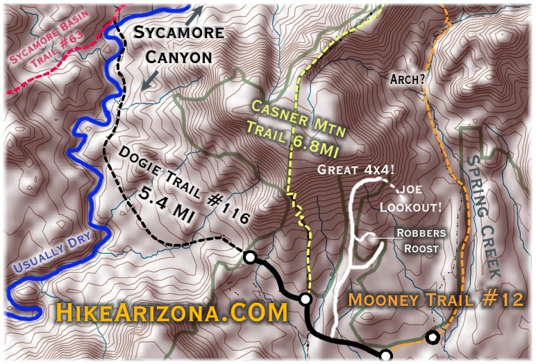
The Dogie Trail offers hikers and horseback'rs a chance to experience the scenic views of the famous red rocks surrounding Sedona without all of the visiting crowds. If solitude is what you seek, this could be the trail for you. The trail descends into the heart of the Sycamore Canyon Wilderness. For those who long for rugged beauty unspoiled and untamed by man, Sycamore is one of the few places in the southwest that can lay claim to such a lack of man's accomplishments. The trail into this primitive area begins at a saddle 200 yards from where you should park your vehicle. Expect a panoramic view of the canyon from this pass.

Javelina, deer, quail, and numerous other animals call this country home. Pinyon pine, juniper, Arizona cypress, brush fields, and wildflowers are abundant.

Make sure you take lots of water for this hike especially during late spring to early fall months. Temperatures quite often exceed 110 degrees in the canyon bottom.

dogie.gif


2002-05-15 HAZ_Hikebot
  • 2021 Verde Valley Trails
    region related
    2021 Verde Valley Trails
  • 2021 Verde Valley Area
    region related
    2021 Verde Valley Area
  • 2021 Sedona Trails Map
    region related
    2021 Sedona Trails Map


Check out the Official Route and Triplogs.
Leave No Trace and +Add a Triplog after your hike to support this local community.

One-Way Notice
This hike is listed as One-Way.

When hiking several trails on a single "hike", log it with a generic name that describes the hike. Then link the trails traveled, check out the example.
WARNING! Hiking and outdoor related sports can be dangerous. Be responsible and prepare for the trip. Study the area you are entering and plan accordingly. Dress for the current and unexpected weather changes. Take plenty of water. Never go alone. Make an itinerary with your plan(s), route(s), destination(s) and expected return time. Give your itinerary to trusted family and/or friends.

 Permit $$
Red Rock Pass - may or may not be required. Go to Red Rock Pass then check "When is a Red Rock Pass Required?". If you have questions contact the Coconino forest service.


 Directions
or
 Road
FR / Jeep Road - Car possible when dry

To Dee Oh Gee Trailhead
From the corner of SR260 & SR89A in Cottonwood Arizona go north on 89A 8.9 miles to FR525. FR525 is 9.6 miles south of the 'Y' if you're coming from Sedona. Go west onto FR525 and follow it 2.8 miles to where FR525C forks off to the left. Follow FR525C to the parking area. Hike the road up to the saddle. The Canyon is not seen from the Parking.

Location: About 50 miles south of Flagstaff (14 miles west of Sedona) on paved and gravelled roads.

Access: Drive 30 miles south from Flagstaff through Sedona on US 89A. Five miles past Sedona turn north on FR 525 and follow the signs to Sycamore Pass. Turn west on FR 525C and continue for nine miles to the parking area. Hike road up to the saddle.

From PHX (I-10 & AZ-51) 127 mi, 2 hours 52 mins
From TUC (Jct 1-10 & Grant) 232 mi, 4 hours 32 mins
From FLG (Jct I-17 & I-40) 49.2 mi, 1 hour 34 mins
 90+° 8am - 6pm kills
helpcorrectionissue

end of page marker