There are several "Robber's Roost" trails in the west, so it's appropriate to designate this as the one in the Superstitions. The name may be personal to our leader; it includes a portion of Carlson and Stewart's Dacite Mesa Loop (trip 20) and Cave Trail (trip 2). Carlson and Stewart omit the "roost" feature, which added much to our hike.
Route finding ability is a must for this adventure. Portions of the route are totally "off-trail", and some stretches are across slick rock with little to guide you.
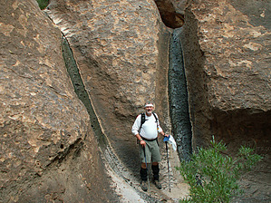
Proceed up the Carney Springs trail; as if there were anything else to do with that brutal grade. At the top, as you stop to breathe and overlook a small drainage that descends to the west, look carefully for a few cairns marking a route off to the NE (right). Count your blessings if, as we found in early March of '03, this and other drainages were running from recent spring showers; it's a rare and wonderful experience. Generally, the route is up this drainage: watch for cairns and a path, but don't obsess over the exact trail; there isn't one. Work your way to the head of the drainage and across the small, level open area. Bear to the left (north), watching for a greenish layer of the smoother rock face in the cliff to your left (north). Below this "marker", make your way into the drainage down (right) to the south-southeast. Be careful. Again, there is no exact route, there are several cairns, and the terrain is definitely "off-trail". Climb and scramble down between and under the rocks till you come to what appears to be the bottom of the bowl... the Roost. (The outlet is a small slot to the southeast.) Note the names and dates chipped into the rocks when wilderness ethics were not well understood. A chimney exits to the west; we chose to go out the way we came because the rocks were wet and rather slick.
Once back out of the bowl, the route winds northeast over to Fremont Saddle. The trick is to stay rather high on the slope, just below the upper layer of hoodoos (vertical columns) until you are west of and directly above Fremont Saddle, then make your descent. Stop at the Gunsight for a photo of Weaver's Needle between the standing pillars.
You can cut things short here and head down Peralta Trail, one of the busiest trails in the entire US Wilderness system, or take the (Geronimo) Cave route back. We took our time and enjoyed the latter, which again requires considerable route finding and a sharp eye for the cairns. Some of the slopes off the cave level are pretty steep; go slow and watch for handholds. You eventually wind up heading down the Bluff Springs trail to Peralta TH, where you can either walk back along the road to the vehicle at the Carney Springs TH or follow along the base of the mountain through the Don's Camp. This is a new trail that Stewart and Carlson do not mention, but it makes a much better hike than the road.
WARNING! Hiking and outdoor related sports can be dangerous. Be responsible and prepare for the trip. Study the area you are entering and plan accordingly. Dress for the current and unexpected weather changes. Take plenty of water. Never go alone. Make an itinerary with your plan(s), route(s), destination(s) and expected return time. Give your itinerary to trusted family and/or friends.
Permit $$
None
Directions
Road
FR / Dirt Road / Gravel - Car Okay
To Lost Goldmine Trailhead 7.6 miles east of the junction Idaho Rd / US-60. Turn Left on to FS77 which is Peralta Road. Follow FS77 5.6 miles to a left and up turnoff. Continue 1.4 miles to the Goldmine Trailhead, turn in left. There's enough parking for a small army. Restrooms are 0.5 miles up the road at Peralta Trailhead.
From PHX (I-10 & AZ-51) 47.1 mi - about 1 hour 10 mins From TUC (Jct 1-10 & Grant) 96.6 mi - about 2 hours 15 mins From FLG (Jct I-17 & I-40) 191 mi - about 3 hours 13 mins
 Route Editor

 There are several "Robber's Roost" trails in the west, so it's appropriate to designate this as the one in the Superstitions. The name may be personal to our leader; it includes a portion of Carlson and Stewart's Dacite Mesa Loop (trip 20) and Cave Trail (trip 2). Carlson and Stewart omit the "roost" feature, which added much to our hike.