Route Editor

| Guide | ♦ | 147 Triplogs | 5 Topics |
details | drive | no permit | forecast | 🔥 route |
stats |
photos | triplogs | topics | location |
| 1.6k | 147 | 5 |
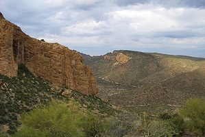
Fabulous Superstition Loop by AZOutdoorsman  I pre-hiked the Marsh Valley Loop for a future trip I will lead for the Sierra Club in April. This large loop is comprised of the combination of four trails (Second Water, Boulder Canyon, Cavalry, and Dutchman's) over 15.5 miles. The trail is relatively flat for its length, with an elevation gain of just over 1500'. The connections are easily identifiable; with most having trail signs at their intersections. The Superstition Wilderness map produced by Beartooth Maps is an excellent resource for anyone spending some time in this magnificent area. All mileage listed is from trail intersection to intersection as stated in the aforementioned map. I pre-hiked the Marsh Valley Loop for a future trip I will lead for the Sierra Club in April. This large loop is comprised of the combination of four trails (Second Water, Boulder Canyon, Cavalry, and Dutchman's) over 15.5 miles. The trail is relatively flat for its length, with an elevation gain of just over 1500'. The connections are easily identifiable; with most having trail signs at their intersections. The Superstition Wilderness map produced by Beartooth Maps is an excellent resource for anyone spending some time in this magnificent area. All mileage listed is from trail intersection to intersection as stated in the aforementioned map.There are still a few sprinkles as I drive toward the First Water trailhead, but it looked like it would clear up and the forecast is promising. I pay my $4.00, park at the TH, and hit the trail to complete the loop in a clockwise manner. There is only one trail from the parking lot, but at .3 miles it forks with Second Water on my left and Dutchman's on my right. As I am doing the hike clockwise today, I take Second Water (236) to the left.
Now I am heading up Boulder Canyon with its massive walls on my left. A short way up the trail on the left side of the creek and just off the left side of the trail is an enormous Saguaro with possibly 20+ arms! It's very impressive and worth a photo. After 1.4 miles on Boulder Canyon, I leave the canyon and take Cavalry (239) that comes in on my left. After a slight climb, I drop down into LaBarge Canyon, which may be even more impressive than Boulder Canyon. After 3.1 miles on Cavalry, the trail Ts at Dutchman's (104) and I take it to the right and will continue on it for the remainder of the hike. As I come up over a small saddle I get my first close-up view of Weaver's Needle! At 0.4 miles from the previous T, there is a fork, with Bull Pass to the right and Dutchman's to the left. I take the left heading up Dutchman's, skirting to the south of Black Top Mesa. The next few miles have many fabulous views of the Needle. After .8 miles from the fork the Terrapin trail comes in on the left, I stay to the right on Dutchman's climbing up over a pass. After 1-mile, Peralta trail is on the left, I proceed on Dutchman's toward Palomino Mountain. As I come up parallel to Palomino Mountain, I see Aylor's Arch up on its ridgeline on the left side of the trail. There is also a crested saguaro in this same area on the opposite side of the trail! I get this saguaro in the skyline with the Needle in the center background and Palomino framing the right side... a great photo (sorry no digital yet). After .8 miles Bull Pass trail is on the right, another .2 and Boulder Canyon is on the right, and another 0.1 and Black Mesa is on the right. I don't take any of these... staying to my left on Dutchman's. I head down the home stretch for another 3.9 miles back to the first fork, which completes the loop. At this point the Second Water trail that I took this morning is on the right, I stay to the left, completing the last 0.3 miles back to the trailhead. WOW! What an awesome hike! The trail was great - well marked, the weather was perfect, and what beautiful scenery. Everything was green, but little to no bloom yet. This time of the year there is water in most of the creeks if you bring your filter. Carlson's, Hiker's Guide To The Superstition Wilderness, and the map previously mentioned are recommended resources. I went at a fairly fast pace with few stops and a short lunch break. I completed the loop in 5 hours 27 minutes. We will take it a little slower on the group outing and take in this glorious country! Enjoy! Check out the Official Route and Triplogs. Leave No Trace and +Add a Triplog after your hike to support this local community. | |||||||||||||||||||||||||||||||||||||||||||||||||||||||||||||||||||||||||||||||||||||||||||||||||||||||||||||||||||