 Route Editor

| Guide | ♦ | 30 Triplogs | 3 Topics |
details | drive | permit | forecast | route |
stats |
photos | triplogs | topics | location |
| 282 | 30 | 3 |
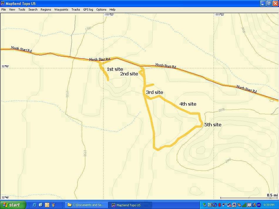
Glyph Hunt by Randal_Schulhauser  A recent trip to the Deer Valley Rock Art Center made me aware of a significant cluster of petroglyphs located in the Picacho Mountains. Having climbed Picacho Peak on more than one occasion, I've been curious about accessing the mountain range on the east side of the I-10. After a little bit of research on the web and I discovered that archeologists had cataloged more than 4000 petroglyphs at 19 distinct sites, with some of the more spectacular displays located at the northern reaches of the Picacho Mountains. Compared to the 1000+ petroglyphs cataloged at the Deer Valley Rock Art Center, another 1000+ at the V-Bar-V Ranch, and 1500+ at the Painted Rocks Petroglyph Site, I figured with 4000+ there are good odds to view some glyphs! A recent trip to the Deer Valley Rock Art Center made me aware of a significant cluster of petroglyphs located in the Picacho Mountains. Having climbed Picacho Peak on more than one occasion, I've been curious about accessing the mountain range on the east side of the I-10. After a little bit of research on the web and I discovered that archeologists had cataloged more than 4000 petroglyphs at 19 distinct sites, with some of the more spectacular displays located at the northern reaches of the Picacho Mountains. Compared to the 1000+ petroglyphs cataloged at the Deer Valley Rock Art Center, another 1000+ at the V-Bar-V Ranch, and 1500+ at the Painted Rocks Petroglyph Site, I figured with 4000+ there are good odds to view some glyphs!With my daughter Hannah home from university for March Break, we headed out on a recent Saturday morning. When you exit the I-10 and travel along Hwy 87, the Picacho Mountains dominate the eastern horizon. Our maps showed East Cornman Road as a direct route east from Hwy 87 to 1st Petroglyph Site along North Start Road. This proved to be a mistake as access is blocked by private lands and threatening signs indicating "Trespassers will be shot!". By-passing the private lands via some off-road trails also proved to be a dead-end due to locked gates near the Central Arizona Project canal. We were back on-track when we traveled Houser Road to Brady Pump Road.
When I parked my truck and exited the vehicle, the first rock encountered seemed covered from end-to-end with petroglyphs. In fact, it appeared that the glyphs were overwritten multiple times including some recent graffiti. The mid-day sun was soon obscured by some quick moving clouds. The softer light revealed petroglyphs on just about every visible rock! We wandered around the perimeter of this boulder strewn hill from the west side to the south side. A cluster of rock art suggesting fertility or pregnancy (stick figures with hollow circles in main body) was found. We continued to find petroglyphs along the south side, albeit more scattered in their concentration. We even found what appeared to be a turtle petroglyph. As Hannah continued to the south, she was startled by a javelina resting in some shaded cover. Not wanting to encounter more boars, we decided to retrace our steps and continue back along the west side of the 1st petroglyph site. We wandered along the north side of the first hill and didn't note any additional glyphs. Near a large standing saguaro skeleton, there is a small cluster of boulders covered with desert varnish. Noting this prime ingredient for rock art, we investigated closer and were soon rewarded. This 2nd petroglyph site seemed to incorporate rock formation features into the rock art. Many of the individual rocks have 4 or 5 parallel lines pecked into the surface. I could spot a 3rd petroglyph site on the west side of the second hill. The rock art style appears markedly different at this site... more psychedelic in my opinion. The rock face seems flatter at this site and may have contributed to the style difference. With noon approaching, it was time for a light snack. We soon continued along the south face of the second hill. Petroglyphs are clustered at a 4th site where a third hill begins. The location of these glyphs isn't necessarily obvious. The path between the 3rd, 4th, and 5th petroglyph sites passes through a saguaro forest. As you approach the 5th petroglyph site, the rocks are considerably weathered and so are the petroglyphs. Careful examination is required to discern the shapes. The loop I've described visits 5 of the 19 petroglyph sites reported in the Picacho Mountains literature. I'd be interested in hearing from others who've visited the other sites and maybe disclose their location. The time we spent at the sites was remarkably peaceful. We only encountered 2 Jeeps making a circuit together along the trail. This route could be an interesting mountain bike journey or a base camp for some hiking opportunities in a remote location. Enjoy! Gate Policy: If a gate is closed upon arrival, leave it closed after you go through. If it is open, leave it open. Leaving a closed gate open may put cattle in danger. Closing an open gate may cut them off from water. Please be respectful, leave gates as found. The exception is signage on the gate directing you otherwise. Check out the Official Route and Triplogs. Leave No Trace and +Add a Triplog after your hike to support this local community. | ||||||||||||||||||||||||||||||||||||||||||||||||||||||||||||||||||||||||||||||||||


