| | -
-
| 1 label | 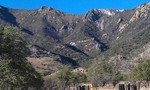 |
|
|
-
-
-
-
-
-
-
-
| 1 label | 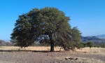 |
|
|
|
| | |
|
| Hiking | 1.46 Miles |
664 AEG |
| | Hiking | 1.46 Miles | 1 Hour 11 Mns | | 2.09 mph |
| 664 ft AEG | 29 Mns Break | 9.5 LBS Pack | | |
|
|
| |
| Linked |
|
none
[ show ]
| no linked trail guides |
| Partners |
|
none
[ show ]
| no partners | | | I took a short afternoon trip out to the backside of the Huachuca Mts. intending to hike up to the end of the 4x4 track (FR 4782) portion of the trail and back down. This would allow myself time to document the hike a bit and do a proper GPS routing of the trail as it is defined on the 'Trail Map of the Huachuca Mountains'. Short and quite steep in places - Copper Canyon provides a canopy to escape the surrounding exposure - as well as a near constant water source to draw from - 'Oak Spring' being one of the lowest elevation springs in the area. Spent the rest of my limited time photography around the region south of the hike's Trailhead and cruising down to the Border Fence via FR 4781 Elevation correction has been applied to the AEG calculation - GPS Route Available |
| _____________________
| | |
|
|
|
|
|
| |
 Route Editor


