• National Geographic Maps → Natl Geographic Society Maps 2009
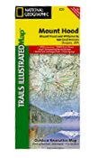
Located just outside Portland, Mt. Hood is the tallest peak in Oregon, the fourth highest in the Cascade Range, and a premier destination for outdoor enthusiasts. The mountain has six ski areas, the renowned Timberline lodge located on the southern flank beside the Palmer Glacier, and is part of the 1.0M acre Mt. Hood National Forest.Our detailed Trails Illustrated recreation map of Mt. Hood contains carefully researched trails, campsites, forest service roads, and points-of-interests. Backcountry users will find the UTM and Latitude/Longitude grids, mileage charts, and other accurate navigation features perfect for exploring the region confidently and safely. Areas included on the map: - Badger Creek, Bull of the Woods, Mount Hood, and Salmon Huckleberry Wilderness Areas. - Newly Legislated Clackamas & Roaring River Wilderness Areas - Clackamas, Collawash, Elkhorn, Roaring River, South Fork Roaring River, White River, Salmon, Eagle Creek, Sandy River, and Fifteen Mile Creek Wild and Scenic Rivers - Pacific Crest and Oregon Trails - South Breitenbush National Scenic Trail - West Cascades and Mount Hood Scenic Byways - Mount Hood National Recreation Area - Opal Creek Scenic Recreation Area - Olallie Lake Scenic Area - Upper Big Bottom Special Protection Area - Oregon State Forests - Santiam and Timothy Lakes - Recreation, Safety, Contact and Wilderness Permit Information - Permit and Information for Climbing Mount Hood Approximately 4 1/4" x 9 1/4" folded; 27" x 39" fully openedScale = 1:75,000Map Revised - 2009
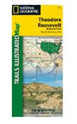
This two-sided map includes both the north and south units of Theodore Roosevelt National Park, as well as the Magpie and Elkhorn section of the Little Missouri Grassland -- providing continuous coverage from north to south. In the North Unit of the park, the map includes the Maah Daah Hey Trail, Little Mo Nature Trail, Caprock Coulee Nature Trail, Buckhorn Trail, Achenbach Trail, and Juniper camping area. The Maah Daah Hey Trail then winds south through the Little Missouri National Grassland, meeting Bennett Trail, then passes into Magpie, then Elkhorn, then into the South Unit of Theodore Roosevelt National Park. Map features in the South Unit include Ridgeline Nature Trail, Coal Vein Nature Trail, Buck Hill Trail, Wind Canyo Trail, Jones Creek Trail, Paddock Creek Trail, Talkington Trail, and the Petrified Forest. Also included in this portion of the map is Buffalo Gap Trail, Roundup Horse Camp, Cottonwood, Painted Canyon, Sully Creek State Park, and the town of Medora. Includes UTM tick marks for use with your GPS unit.
• Trails Illustrated → Rand McNally & Company 1999
This map of the Lake Mead National Recreation Area includes Virgin Mountains, Black Mountains, Valley of Fire State Park, North Muddy Mountains, Detrital Valley, Newberry Mountains, El Dorado Mountains, White Hills, Mt. Wilson Wilderness Hoover Dam. Towns: Boulder City; Overton. Includes UTM grids for use with your GPS unit.
• National Geographic Maps → Natl Geographic Society Maps 2006
The map includes all of North Cascades National Park, Ross Lake National Recreation Area, and Lake Chelan National Recreation Area, with detailed trails and topographic information. The map includes detailed coverage of Mount Baker Wilderness, Snoqualmie National Forest, Glacier Peak Wilderness, Stephen Mather Wilderness, Ross Lake National Recreatioin Area, Noisy Diobsub Wilderness, Pasayten Wilderness, Wenatchee National Forest, Lake Chelan, Ross Lake, and much more. Includes UTM grids for use with your GPS unit.Approximately 4 1/4" x 9 1/4" folded; 26'' x 38'' Scale = 1:100,000
 Mt. Hood & Willamette National Forest - Trails Illustrated Map #820
 Nantahala and Cullasaja Gorges, NC - Trails Illustrated Map # 785 (National Geographic Maps: Trails
 National Geographic Badlands National Park: South Dakota, USA/ Trails Illustrated Map (National Geog
 National Geographic Grand Canyon National Park Arizona, USA: Trails Illustrated
 National Geographic Trails Illustrated Olympic National Park: Washington, USA
 National Geographic Trails Illustrated Shenandoah National Park: Virginia USA
 National Geographic Trails Illustrated Theodore Roosevelt National Park: North Dakota, USA
 National Geographic, Trails Illustrated, Acadia National Park: Maine, USA
 National Geographic, Trails Illustrated, Lake Mead National Recreation Area: Arizona/Nevada, USA
 North Cascades National Park, WA - Trails Illustrated Map #223

 Route Editor

