username
X
password
register
for free!
help
  🔥

Superstition Mtns - SW / Nosepicker Pinnacles, AZ

Guide 4 Triplogs  0 Topics
  3.5 of 5  
Fav
Wish
0
details
drive
no permit
forecast
🔥
route  
stats
photos
triplogs
topics
location
26 4 0
Warning! Technical climbing skills required. Risks include serious injury to death.  Risks are not eliminated by skill.
Historical Weather
Trailhead Forecast
Radar Map
Expand Map
Preferred Oct, Nov, Mar, Apr → 6 AM
Seasons   Autumn to Spring
Sun  7:14am - 5:17pm
Official Route
 
0 Alternative
 
Historic Fire Perimetersacres
🔥 2024 Siphon Fire35.9 mi*
🔥 2020 Sawtooth Fire24.7k
🔥 2019 Woodbury Fire123.8k
🔥 View (All) - over Official Route 🔥
*perimeter length in miles


feature photo
Photos Viewed All MineFollowing
4  2025-11-08
Cave - Peralta loop
pseudalpine
17  2019-11-02 FOTG
5  2019-11-02 pseudalpine
Climb Section

+Add your Photos & Triplogs!
You can add routes when posting a triplog
L>R Routes Rated Difficulty Trips
The Wee ChimneyT 5.6 1
Bombs AwayT 5.10a R1
Doomed For ObscurityS 5.9 1
The CucumberT 5.9
Do It CleanT 5.7 R
KleenexT 5.6 PG 98 ft1
Login for beta
Superstition CurleyT 5.4 69 ft1
Login for beta
UlyssesT 5.7 1
+Add > Triplog to share climbs & add routes
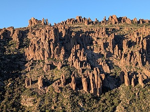
Gotta Boogie on My Finger
by pseudalpine

Expand MapOverview
The Nosepicker Pinnacles are situated above the Peralta Trail below Fremont Saddle on the west side of the steep canyon. The lower linear grouping of four pillars and Ulysses isolated from them a few hundred feet above, has a few difficult, moderate, and easy routes, both sport and trad. From north to south, left to right facing east, the first tower is the tallest (two routes), then a smaller one named The Cucumber has three challenging routes, third is Kleenex (tricky finish, don’t blow it), and the last, smallest, more mellow apex is the endearing Superstition Curley.


Approach
After 1.63 miles, one must leave the Peralta Trail and bear west up some moderately vegetated talus. It’s not as bad as it looks from below, and some limited use would help clear a better path. Review the Official Route to notice this point is at a set of isolated switchbacks south of the long straightaway before the final set of switchbacks below Fremont Saddle. If the group’s session includes the upper Ulysses climb, the total trip distance would approximately be 3.8 miles and 1450 AEG.
remove free decal offer
Synopsis
As with Zonerland and the Land of Nod located uphill to the northwest, these five pinnacles obviously aren’t the only worthy volcanic towers in the area. Multitudes of other spires in the vicinity could have possible routes developed. Consequently, one would then have to consider the proximity of this area to one of the most traveled trails in the Wilderness and the negative ramifications that could create. Unfortunately, not everyone’s comfortable dancing the boogie-woogie.

2025-11-09 pseudalpine


    Check out the Official Route and Triplogs.
    Leave No Trace and +Add a Triplog after your climb trip to support this local community.
    WARNING! Hiking and outdoor related sports can be dangerous. Be responsible and prepare for the trip. Study the area you are entering and plan accordingly. Dress for the current and unexpected weather changes. Take plenty of water. Never go alone. Make an itinerary with your plan(s), route(s), destination(s) and expected return time. Give your itinerary to trusted family and/or friends.

     Permit $$
    None


     Directions
    or
     Road
    FR / Jeep Road - Car possible when dry

    To Peralta Trailhead
    7.6 miles east of the junction Idaho Rd / US-60. Turn Left on to FS77 which is Peralta Road. Follow FS77 5.6 miles to a left and up turnoff. Continue 1.9 miles to Peralta Trailhead.

    The trailhead has restrooms minus running water. The parking lot is enormous. It does fill up in season on weekends. Since there are no lines, the rangers ask that you park straight between the posts in the main lot. Please do your part with this simple request and make room for the next guy. 0.5 miles before reaching the trailhead is an overflow lot, which is also suited for horse trailer parking.

    From PHX (Jct I-10 & AZ-51) 45.2 mi - about 1 hour 8 mins
    From TUC (Jct 1-10 & Grant) 97.0 mi - about 2 hours 16 mins
    From FLG (Jct I-17 & I-40) 192 mi - about 3 hours 15 mins
    page created by FOTG on Nov 03 2019 2:30 pm
    helpcorrectionissue

    end of page marker