 Route Editor

| Guide | ♦ | 5 Triplogs | 0 Topics |
details | drive | no permit | forecast | 🔥 route |
stats |
photos | triplogs | topics | location |
| 4 | 5 | 0 |
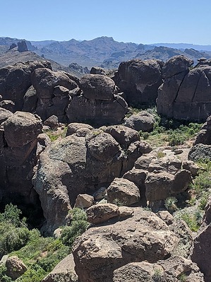
Because People Are Dying to Get In by pseudalpine   Overview OverviewThe Cemetery is predominantly a bouldering area that overlaps with The Labyrinth located behind (west) of Barks Canyon Wall. There are a few actual climbing routes within this otherworldly maze but most of them are systematically listed within the Myth or Bark Canyon Walls guides for organizational reasons. Compared to The Fortress, several sit start Supe’s test pieces may be sent, assuming one didn’t forget to wear their beanie. Approach At ~1.37 miles, one must scramble over the cemetery gate. No worries though because the enchanting Lacy Iron isn’t particularly high or challenging to clear (cl.3 chicken heads). Traverse east (right) to more easily cross the obvious large yellow/green lichen slab. Finally, pass north through a shallow, brushy gap to transition into the graveyard at the 1.5-mile mark. It likely takes less than an hour to get a glimpse of the obvious and prominent Helmet megalith.
The grounds are currently in a sullen state from a previous wildfire, but at the same time, there are promising green shoots of resurrection. Many of the headstone, monument, and pillar problems stand in extant remembrance, unaffected by the quick-burning fire. Not only is this necropolis sequestered but also most importantly, an extremely tranquil setting to chase shadows, endure, and reflect. Gate Policy: If a gate is closed upon arrival, leave it closed after you go through. If it is open, leave it open. Leaving a closed gate open may put cattle in danger. Closing an open gate may cut them off from water. Please be respectful, leave gates as found. The exception is signage on the gate directing you otherwise. Check out the Official Route and Triplogs. Leave No Trace and +Add a Triplog after your climb trip to support this local community. | |||||||||||||||||||||||||||||||||||||||||||||||||||||||||||||||||||||||||||||||||||||||||||||||||||||||||||||||||||||||||||||||||||||||||||
 Rated
Rated
