Route Editor

| Guide | ♦ | 2 Triplogs | 0 Topics |
details | drive | no permit | forecast | map |
stats |
photos | triplogs | topics | location |
| 11 | 2 | 0 |
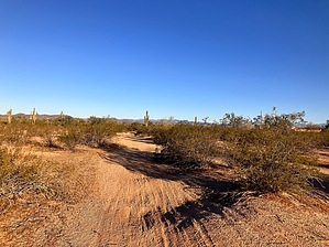
This biscuit needs gravy by mt98dew  Overview OverviewThe Paloma Regional Preserve is a new park that opened in October 2020. The park comes loaded with amenities, including a dog park (actually 2, one for big dogs and one for small), baseball fields, a splash park, fishing, picnic tables, pickleball courts, bathrooms, drinking fountains, and even a few trails. The trails were one of the last features added, and it seems to still be a work in progress. In addition to adding 11 new trails, they’ve changed the names of the trails that traverse West Wing Mountain. (The trails are the same on West Wing Mountain; they have just given different segments of trails their own name). The park and all the above amenities are accessed via N Lake Pleasant Rd. Not including the TH described in the West Wing Mountain description, 3 trailheads access the new trails that are part of the Paloma Regional Preserve (PRP). One is located at the East Wing TH, and the other 2 are located in Paloma Park on the west end of the preserve. (The preserve extends between East Wing TH and Paloma Park). The East Wing TH, though not as large, has a few amenities of its own, including bathrooms, basketball courts, a playground, drinking fountains, and a trail map of the area (located at the trailhead). The Biscuit Flat Trail is most easily accessed from the East Wing TH. There is parking for about 20 cars, and the TH is located at the northwest edge of an open field.
Many of the trails that make up the Paloma Regional Preserve are trails that have been repurposed as “new” trails for the Preserve. This can lead to confusion as there are numerous unnamed paths and roads in the Preserve created by hikers, bikers, and off-road enthusiasts long before the Preserve existed. Hike The Biscuit Flat Trail is a two-arm loop trail. One of the arms takes off from the TH in a northwest direction. There is no signage at the start, but there is a trail map to give you some guidance. Initially, the trail is a 3ft wide dirt track that twists back and forth as it maintains its NW direction. There will be multiple threads that spin off this trail. Some will weave back into Biscuit Flat, and others will go off on their own accord. At 0.4 miles, you reach the beginning of the loop and your first trail marker. This is a loop trail, so going either direction will bring you back to this point. Going CCW, the trail heads east for 0.12 miles before turning sharply to the north. This turn is signed, but it’s not a huge deal because by this time, the trail has become a 5ft road, and its path has become very evident. The northward stretch is fairly straight and seems obvious, but at .9 miles the Biscuit Flat Trail turns to the west. This turn is unexpected because it goes from a “road” to a faint trail and is unsigned. This faint trail only lasts for about 0.1 miles before reaching a trail marker indicating the Biscuit Flat Trail heading south. Once again, this trail becomes more like a road and has annoying stretches of sandy conditions. At 1.38, the Biscuit Flat reaches a 4-way intersection and its next trail marker. Turning right is the second arm of the Biscuit Flat Trail, and in 0.15 miles, it will bring you to the New River Trail. (Continuing straight at this marker is an unsigned use trail). Turning left keeps you on the loop, and in 0.2 miles, you have closed the loop. Return to the TH via the first arm of the Biscuit Flat Trail. Water Sources Water is available at the Sonoran Ranch Park. Synopsis The Biscuit Flat is a very anemic trail that doesn’t have much going for it. It appears that Peoria tried to take advantage of some use trails/roads in the area and create a trail out of it. Wouldn’t be as bad if they had been able to put up proper signage to go with the trail, but that being said, there are use-trails in the area that have more “character” than Biscuit Flat. This trail is ok to get from one trail to another, but it is probably only desirable to locals who would rather walk a desert trail than a sidewalk.
Check out the Triplogs. Leave No Trace and +Add a Triplog after your hike to support this local community. | ||||||||||||||||||||||||||||||||||||||||||||||||||||||||||||||||||||||||||||||||