 Route Editor

| Guide | ♦ | 7 Triplogs | 3 Topics |
details | drive | no permit | forecast | 🔥 route |
stats |
photos | triplogs | topics | location |
| 115 | 7 | 3 |
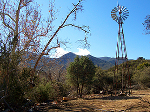
brushy banality by PrestonSands   2026-02-09 2026-02-09The managing agency Tonto National Forest lists this trail as Closed. The Check Dam Trail #190 serves as a connector between the Sixshooter Trail #197 and the Tollroad Trail #200. It is one of several trails that criss-cross the northern foothills of the Pinal Mountains, south of Globe. The Check Dam Trail was named for the erosion control dams constructed in the area by the Civilian Conservation Corps during the 1930s.
Starting at the Icehouse C.C.C. trailhead, begin following the Sixshooter Trail #197 southeast through the dense, shoulder-high chaparral of the Pinal Mountain foothills. After about a half mile or so, you will come to the signed junction with the Check Dam Trail #190. The Check Dam Trail makes an immediate u-turn and begins heading north. The trail makes a gradual descent between walls of dense brush and soon turns northeast. Numerous cowpies and possibly some actual cows will greet you along this stretch. The trail soon bottoms out along Pinal Creek, among the sycamore and hackberry trees. There is a working windmill along the trail to your right in this area. The Check Dam Trail appears to dead end here at a dirt road, just past the windmill. Although this area is a little confusing, the trail does continue from here. Look carefully for the cairn I built (33.33405 N, 110.78887 W) next to the road. The trail heads east from this point, paralleling and then crossing Pinal Creek. The Check Dam Trail now continues east, following a little dry wash up to a 4100-foot saddle. Beyond the saddle, the trail drops down into the high desert and arrives at a junction (33.33370 N, 110.77915 W) with the Tollroad Trail #200 after about a quarter mile. Return the way you came, or turn onto the Tollroad Trail. If you turn left (north) onto trail #200, it is about 0.8 miles to the Tollroad Trailhead. If you turn right, it is 2 miles up to the Una Del Oso Trail where the possibility for the loop hike exists. Check out the Official Route and Triplogs. Leave No Trace and +Add a Triplog after your hike to support this local community. One-Way Notice This hike is listed as One-Way. When hiking several trails on a single "hike", log it with a generic name that describes the hike. Then link the trails traveled, check out the example. | ||||||||||||||||||||||||||||||||||||||||||||||||||||||||||||||||||||||||||||||||||||||||||||||||||||||||||||||


