username
X
password
register
for free!
help
 

Kaiser Spring Canyon, AZ

Guide 10 Triplogs  0 Topics
  4 of 5  
Fav
Wish
9
details
drive
no permit
forecast
route  
stats
photos
triplogs
topics
location
110 10 0
Statistics
tap row or icons for details
Difficulty 2.5 of 5
Route Finding 1 of 5
Distance One Way 4.8 miles
Trailhead Elevation 1,999 feet
Elevation Gain 879 feet
Accumulated Gain 1,093 feet
Avg Time One Way 2.5 hours
Kokopelli Seeds 8.44
 Interest Seasonal Waterfall
feature photo
Photos Viewed All MineFollowing
Will recalculate on button tap!
6  2022-04-23 azbackpackr
14  2021-11-27
Burro Creek
chumley
22  2013-02-02
Burro Creek - Kaiser Roll Canyon Loop
joebartels
25  2013-02-02
Burro Creek-Kaiser Canyon Loop
The_Eagle
11  2011-11-02 ASUAviator
7  2009-02-28 Lizard
24  2008-03-22 ankaa
1  2008-03-22 ankaa
Author
author avatar Guides 16,843
Routes 17,472
Photos 24
Trips 1 map ( 6 miles )
Age 28 Male Gender
Location HAZ, TrailDEX
Associated Areas
list map done
Northwest Region
Historical Weather
Trailhead Forecast
Radar Map
Expand Map
Preferred Feb, Jan, Dec, Mar → 8 AM
Seasons   ALL
Sun  6:10am - 6:55pm
Official Route
 
2 Alternative


remove free decal offer
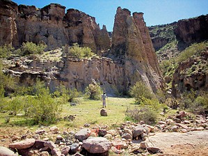
Warm Spring/Narrow Canyon
by HAZ_Hikebot

Guide Needed
Publish Full Detail Guide


Use +Add above to share photos and triplogs
Hike Location
Kaiser Canyon, Near Burro Creek Campground

Trail Surface
Good with loose footing in places. Hiking in the wash & climbing boulders


  • guide related image
    guide related


Check out the Official Route and Triplogs.
Leave No Trace and +Add a Triplog after your hike to support this local community.

One-Way Notice
This hike is listed as One-Way.

When hiking several trails on a single "hike", log it with a generic name that describes the hike. Then link the trails traveled, check out the example.
WARNING! Hiking and outdoor related sports can be dangerous. Be responsible and prepare for the trip. Study the area you are entering and plan accordingly. Dress for the current and unexpected weather changes. Take plenty of water. Never go alone. Make an itinerary with your plan(s), route(s), destination(s) and expected return time. Give your itinerary to trusted family and/or friends.

 Permit $$
None


 Directions
or
 Road
FR / Dirt Road / Gravel - Car Okay

To hike
Take Hwy 60 from Surprise into Wickenburg, leave Wickenburg NW on Hwy 93. Drive about 70 miles to just after mile marker 135, turn right and park under bridge. It's an unimproved dirt road used for less than 500 feet. Most cars should be OK.
 90+° 8am - 6pm kills
helpcorrectionissue

end of page marker