username
X
password
register
for free!
help
 This is likely a great time to hike this trail!  Check out "Preferred" months below, keep in mind this is an estimate.
 

Whispering Spruce Trail - WV Highpoint, WV

Guide 2 Triplogs  0 Topics
  0 of 5  
Fav
Wish
0
details
drive
no permit
forecast
route  
stats
photos
triplogs
topics
location
10 2 0
Statistics
tap row or icons for details
Difficulty 0.5 of 5
Route Finding 1 of 5
Distance Round Trip 0.53 miles
Trailhead Elevation 4,830 feet
Elevation Gain 15 feet
Accumulated Gain 16 feet
Kokopelli Seeds 0.61
unreported if dogs are allowed
editedit > ops > dogs to adjust
feature photo
Photos Viewed All MineFollowing
Inaugural Calculation on Button Tap!
15  2020-10-07
Huckleberry Trail
Stoic
10  2018-06-25 Daytripper
Author
author avatar Guides 16,843
Routes 17,472
Photos 24
Trips 1 map ( 6 miles )
Age 28 Male Gender
Location HAZ, TrailDEX
Associated Areas
list map done
Eastern Panhandle Region
Historical Weather
Trailhead Forecast
Radar Map
Expand Map
Preferred Jul, Aug, Jun, Sep
Sun  4:51am - 5:43pm
Official Route
 
1 Alternative


remove free decal offer

 Likely In-Season!
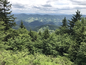
Encircles the Spruce Knob tower. Visitors can feel what life is like for the plants and animals living above 4,000 feet in the Allegheny Mountains. This nature trail winds through windblown rock where one can feel the sharp west wind blow. It then leads out to a point where giant boulders are scattered through an open field. Exceptional views to the east and west are seen beyond. From this point the trail enters a thick spruce patch protected from the wind where visitors can peek through breaks in the trees to see the North Fork valley below and the mountains fading into Virginia. Beyond the stand of spruce, the trail forks; left leads back to the tower and right leads through a blueberry patch speckled with azalea bushes before reaching the parking lot. The wide hard gravelled path has gentle slopes.

2018-07-14 HAZ_Hikebot


    Check out the Official Route and Triplogs.
    Leave No Trace and +Add a Triplog after your hike to support this local community.
    WARNING! Hiking and outdoor related sports can be dangerous. Be responsible and prepare for the trip. Study the area you are entering and plan accordingly. Dress for the current and unexpected weather changes. Take plenty of water. Never go alone. Make an itinerary with your plan(s), route(s), destination(s) and expected return time. Give your itinerary to trusted family and/or friends.

     Permit $$
    no fees or permits reported

    if incorrect tell us about it


     Directions
    or
     Road


    To hike
    page created by HAZ_Hikebot on Mar 09 2010 6:50 pm
     90+° 8am - 6pm kills
    helpcorrectionissue

    end of page marker