 Route Editor

| Guide | ♦ | 2 Triplogs | 0 Topics |
details | drive | no permit | forecast | route |
stats |
photos | triplogs | topics | location |
| 5 | 2 | 0 |
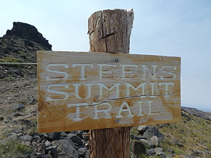
A short hike to the summit of the Steens Mountain offers 360-degree views. On a clear day it is said that you can see Idaho, Nevada, and California as well as Mount Shasta. Warning It is advised to stay off the summit if there’s a chance of lightning strikes.
Originally called the "Snowy Mountains" by John Work, one of the first European fur traders in the area, Steens Mountain was later renamed for United States Army Major Enoch Steen. Steen fought and drove members of the Paiute tribe off the mountain after abandoning road survey work he was ordered to conduct in the area. In 2000 the Steens Mountain Wilderness was formed. The 170,200+ acres is managed by the Bureau of Land Management. The Hike From the signed trailhead the hike is along an old Jeep road. Initially the trail is somewhat steep, but it quickly levels off to a more gradual climb. Along the way you can see Wildhorse Lake to the southwest. Once on top you can look down onto the Alvord Playa, to the east. There are numerous antennas at the summit. Just ignore them and enjoy the views. Check out the Official Route and Triplogs. Leave No Trace and +Add a Triplog after your hike to support this local community. One-Way Notice This hike is listed as One-Way. When hiking several trails on a single "hike", log it with a generic name that describes the hike. Then link the trails traveled, check out the example. | |||||||||||||||||||||||||||||||||||||||||||||||||||||||||||||||||||||||||||||||


