 Route Editor

| Guide | ♦ | 71 Triplogs | 1 Topic |
details | drive | permit | forecast | route |
stats |
photos | triplogs | topic | location |
| 903 | 71 | 1 |
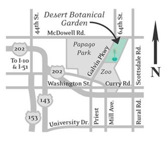
  A beautiful surprise awaits anyone who visits the Desert Botanical Garden located just east of downtown Phoenix where Scottsdale, Tempe, and Phoenix come together. After visiting the nearby Phoenix Zoo recently I became aware of these 145 acres of desert plants just up the road from the zoo and part of the Papago Park. We spent almost 4 hours there and all I can say is that I am very, very impressed with the presentation of every possible type of desert flower and plant that exists. Hundreds of desert plants are here; many are endangered and, as photos show, many are quite distinct and interesting looking. A beautiful surprise awaits anyone who visits the Desert Botanical Garden located just east of downtown Phoenix where Scottsdale, Tempe, and Phoenix come together. After visiting the nearby Phoenix Zoo recently I became aware of these 145 acres of desert plants just up the road from the zoo and part of the Papago Park. We spent almost 4 hours there and all I can say is that I am very, very impressed with the presentation of every possible type of desert flower and plant that exists. Hundreds of desert plants are here; many are endangered and, as photos show, many are quite distinct and interesting looking.At the admission gate, you are given a very detailed trail map. There is a main trail that winds its way through the center of the garden and then there are 8 sub trails that one can take off of the main brick pathway. Each of the sub-trails features special interest plants like herb gardens, flowers, cacti and succulents.
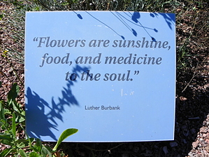
We were extremely impressed with the upkeep and condition of the garden which show a great deal of care. While similar to the Boyce-Thompson Arboretum near the town of Superior, this beautiful area is basically right in the middle of a city. The trail network is not quite as long but the plant selection is excellent. Other than a constant stream of planes taking off and landing at Sky Harbor Airport, there is lots of quiet. At times you feel you are really in a desert oasis. We think this entire display is very tastefully done and top quality. Every plant has a little sign telling what it is and its botanical name. We noticed lots of school groups touring. Don't miss this great desert display. I am so used to the rocky trails in the Superstitions that I approached this with just mild interest until I got there. Now I am sorry I did not come here before. There is an entrance fee for adults. Very worthwhile! 2010-08-08 paulshikleejr The Garden comprises five main loops (narrative text from official DBG literature, distance, and AEG from GPS track): Desert Discovery Loop Trail: 0.36 mile, 21 AEG Follow the brick path: take the Garden's main trail and learn the unique characteristics of desert plants from around the world. The loop trail features outstanding displays and exhibits including the Sybil B. Harrington Cactus and Succulent Galleries and the Berlin Agave Yucca Forest. Along the way, explore the great diversity of form, texture, and color found in this wondrous array of cacti and succulents from around the world. Plants & People of the Sonoran Desert Loop Trail: 0.41 mile, 26 AEG Discover how Sonoran Desert plants have been used for food, fiber, medicine, and other cultural purposes. Pound mesquite beans into flour and step inside a traditional Akimel O'odham Roundhouse. Closed at sunset. Sonoran Desert Nature Loop Trail: 0.24 mile, 29 AEG Change your point of view on this trail which features dramatic vistas of distant mountains and up-close views of the surrounding desert. A variety of fascinating exhibits focus on both the plants and animals of the Sonoran Desert. Closed at sunset. Steele Herb Garden: 0.12 mile, 7 AEG Become familiar with a variety of desert-adapted herbs. Highlights include: A Wildlife Garden, a Picante Garden, a Tea and Culinary Garden, and a Medicinal Garden. Closed at sunset. Harriet K. Maxwell Desert Wildflower Loop Trail: 0.41 mile, 15 AEG On this trail, you will see how wildflowers attract hummingbirds and butterflies (and people, too). Discover the beauty, color, and diversity of wildflowers in North American deserts, and how they play a role in the desert's ecosystem. Closed at sunset. Gate Policy: If a gate is closed upon arrival, leave it closed after you go through. If it is open, leave it open. Leaving a closed gate open may put cattle in danger. Closing an open gate may cut them off from water. Please be respectful, leave gates as found. The exception is signage on the gate directing you otherwise.
Check out the Official Route and Triplogs. Leave No Trace and +Add a Triplog after your hike to support this local community. | ||||||||||||||||||||||||||||||||||||||||||||||||||||||||||||||||||||||||||||||||||||


