Route Editor

| Guide | ♦ | 16 Triplogs | 0 Topics |
details | drive | no permit | forecast | 🔥 route |
stats |
photos | triplogs | topics | location |
| 54 | 16 | 0 |
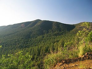
adrift in a sea of pine by PrestonSands   McFadden Peak, the site of one of two fire lookouts in the Sierra Ancha, offers continuous views of the surrounding areas. This peak was named for William McFadden, who started the Circle Ranch on McFadden Creek. McFadden had been part of a vigilante group during the Pleasant Valley War and later settled in the Sierra Anchas to get away from the feud. There are two routes to the top of this 7135-foot peak: the short way (forest road 561), and the long way (McFadden Park Trail). I haven't hiked the McFadden Park Trail yet, so I'll describe the short way up. McFadden Peak, the site of one of two fire lookouts in the Sierra Ancha, offers continuous views of the surrounding areas. This peak was named for William McFadden, who started the Circle Ranch on McFadden Creek. McFadden had been part of a vigilante group during the Pleasant Valley War and later settled in the Sierra Anchas to get away from the feud. There are two routes to the top of this 7135-foot peak: the short way (forest road 561), and the long way (McFadden Park Trail). I haven't hiked the McFadden Park Trail yet, so I'll describe the short way up.Park your vehicle at the locked gate at the beginning of forest road 561, next to highway 288. Be careful not to block the gate, in case the forest service needs to use the road. As you hike up the 561 road, bird's eye views of the forested Sierra Ancha begin immediately. The road makes a continuous and even ascent along the southern slope of McFadden Peak, through the mountain's pale, Troy Quartzite rock. The vegetation on this stretch includes pinyon pine, alligator juniper, and mountain mahogany, all of which are low enough to allow for wonderful views of the surrounding mountains. In the valley far below is the long, grassy meadow of the Circle Ranch. At about 1.1 miles, the road rounds the western side of McFadden Peak, where it meets the McFadden Park Trail coming in from the west. A wooden sign marks the junction. Now on the north side of the mountain, the road is shaded by Gambel oaks and ponderosa pines, and soon reaches the top of the peak. A short fire tower, listed as a historic fire lookout, sits at the summit. There are spectacular views in all directions here. Superstition Mountain, the Mogollon Rim, the White Mountains, and everything in between can be seen. Return the way you came, or, if someone has left a shuttle vehicle at the Circle Trailhead, you can take the McFadden Park Trail back. Gate Policy: If a gate is closed upon arrival, leave it closed after you go through. If it is open, leave it open. Leaving a closed gate open may put cattle in danger. Closing an open gate may cut them off from water. Please be respectful, leave gates as found. The exception is signage on the gate directing you otherwise. Check out the Official Route and Triplogs. Leave No Trace and +Add a Triplog after your hike to support this local community. | ||||||||||||||||||||||||||||||||||||||||||||||||||||||||||||||||||||||||||||||||||||||||||||||||||||||||||||||||||||||||||||||||||||||||||||||||||||||||||||||||||||||||||||||||||||||||||||||||||||||||