Overview
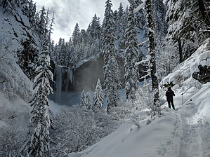
Nice easy hike to a stunning 100 foot waterfall on the east side of Mt. Hood. Makes for a very popular winter hike when the basalt amphitheater is coated in frozen ice from waterfall spray.
Hike
From the Tamanawas Falls trailhead, head north and cross a wooden bridge over the East Fork Hood River. On the far side of the bridge you will be met with your first trail junction- turn right and follow the trail as it continues north. You will parallel highway 35 for about a 1/2 mile as the trail climbs a small ridge above the river.
The trail will eventually turn west and descend to a second smaller wooden bridge that spans Cold Spring Creek. Cross the bridge and follow the trail as it now winds along the creek. In about 3/4 of a mile the trail will pass a spur trail on the right at the beginning of a large boulder field. When I passed through in February 2018, this junction was marked with a temporary sign and easy to miss. Continue straight past the junction and follow the trail as it winds through the boulder field. From here its only another 1/4 mile of easy hiking until to you arrive at Tamanawas Falls.
WARNING! Hiking and outdoor related sports can be dangerous. Be responsible and prepare for the trip. Study the area you are entering and plan accordingly. Dress for the current and unexpected weather changes. Take plenty of water. Never go alone. Make an itinerary with your plan(s), route(s), destination(s) and expected return time. Give your itinerary to trusted family and/or friends.
Permit $$
Oregon Forest - Recreation Pass ($5 per day or $30 per year)
To hike From Government Camp, drive east on Highway 26 for just over 2 miles, then take the split to Highway 35/Hood River. Continue driving north for 14.8 miles, the trailhead will be on the left side of the road and has room for about a dozen cars.
page created by HAZ_Hikebot on Feb 28 2018 3:31 pm
 Route Editor