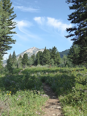
On our way over to West Yellowstone we decided to take a short hike on a highly recommended trail in the Targhee National Forest. The trail was easy to follow and the wildflowers were splendid and abundant. While we could hear Targhee Creek below us the whole time, we only got glimpses of it now and again.
Shortly after the cut-off for Dry Fork (which you could use to make a loop with Targhee Creek trail), my husband noticed a path going off to the left. Why not? Maybe it leads to the creek? Lo and behold, it did! Much to our surprise, next to the creek was the frame of a teepee. And in the bend of the creek looked like a very fine water hole for cooling off. If you're a backpacker, this would definitely be a place to spend the night. We turned around after an hour and enjoyed chatting with the other hikers (and horse riders) coming up the trail.
The national forest website says "Special attractions along the trail include five alpine lakes amid the mountains, abundant wildlife, wildflowers, and great scenic views of the mountains and valley floor. The Targhee Creek Trail is located in Grizzly Bear habitat and if camping overnight along the trail, use the bear-proof storage containers provided or hang your food appropriately.".
When hiking several trails on a single "hike", log it with a generic name that describes the hike. Then link the trails traveled, check out the example.
WARNING! Hiking and outdoor related sports can be dangerous. Be responsible and prepare for the trip. Study the area you are entering and plan accordingly. Dress for the current and unexpected weather changes. Take plenty of water. Never go alone. Make an itinerary with your plan(s), route(s), destination(s) and expected return time. Give your itinerary to trusted family and/or friends.
Permit $$
FS
Directions
Road
FR / Dirt Road / Gravel - Car Okay
To hike Located 16 miles north of the Island Park Ranger Station and 10 miles west of West Yellowstone, MT. Travel north 15 miles on Highway 20 then turn west on Forest Road #057. This road leads directly to the Targhee Creek Trailhead.
page created by HAZ_Hikebot on Jul 22 2017 4:54 pm
 Route Editor


