username
X
password
register
for free!
help
  

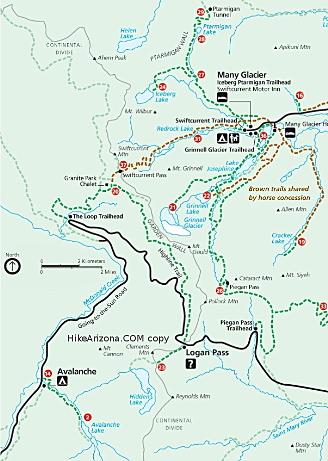
The Northern Highline, MT

Guide 2 Triplogs  0 Topics
  5 of 5  
Fav
Wish
0
details
drive
permit
forecast
map
stats
photos
triplogs
topics
location
105 2 0
Statistics
tap row or icons for details
Difficulty 2.5 of 5
Distance 23.8 miles
Trailhead Elevation 4,328 feet
Elevation Gain 1,910 feet
Kokopelli Seeds 30.17
unreported if dogs are allowed
editedit > ops > dogs to adjust
Photos Viewed All MineFollowing
68  2021-08-11
Ahern Pass via Chalet
tibber
37  2016-08-08
Swiftcurrent Pass
Lucyan
Author
author avatar Guides 16,832
Routes 17,471
Photos 24
Trips 1 map ( 6 miles )
Age Male Gender
Location HAZ, TrailDEX
Associated Areas
list map done
Western Region
Historical Weather
Trailhead Forecast
Expand Map
Preferred Jun, Sep, Jul, Aug
Sun  7:03am - 5:36pm
0 Route
 
1 Alternative


remove free decal offer

Expand Map

Happy

Trails!


  • goat haunt map st mary map mcdonald map
    area related


Check out the Triplogs.
Leave No Trace and +Add a Triplog after your hike to support this local community.
WARNING! Hiking and outdoor related sports can be dangerous. Be responsible and prepare for the trip. Study the area you are entering and plan accordingly. Dress for the current and unexpected weather changes. Take plenty of water. Never go alone. Make an itinerary with your plan(s), route(s), destination(s) and expected return time. Give your itinerary to trusted family and/or friends.

 Permit $$
no fees or permits reported

if incorrect tell us about it

Glacier National Park
$30 per car(week), $12 bike/foot(week), $50 annual View Current Entrance Fees


 Directions
or
 Road


To hike
page created by HAZ_Hikebot on Mar 09 2010 6:59 pm
helpcorrectionissue

end of page marker