Route Editor

| Guide | ♦ | 44 Triplogs | 8 Topics |
details | drive | no permit | forecast | 🔥 route |
stats |
photos | triplogs | topics | location |
| 518 | 44 | 8 |
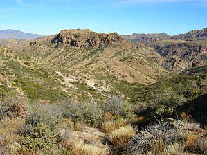
In love with catclaw by HAZ_Hikebot   If you are not from Arizona or have never hiked in Arizona but would like to see most of what the state has to offer as far as a backpacking trip, this is the trail for you! If you are not from Arizona or have never hiked in Arizona but would like to see most of what the state has to offer as far as a backpacking trip, this is the trail for you!The road to the trailhead is just as Joe describes it... ROUGH! I had a rental car that, let's say, performed great, but I held my breath on several occasions waiting to see the oil light come on because I ripped the oil pan clean off, but as luck was on my side, this did not happen. Plan early and reserve that SUV.
The trail was incredible. It starts with typical Arizona flora, which was great to hike amongst for that "up close and personal" experience. As mentioned above, if you follow along in the book, do not bother looking for the "weathered green sign" that says TRAIL. It is no longer there. To save yourself some time hunting for the correct travel direction (many possible tracks resemble trails from those lost soles seeking the proper way to proceed), you stand facing it when you get to the windmill. The trail is at approximately 8 o'clock from the windmill. After crossing the river several times, brace yourself for a continual climb in elevation to Tortilla Pass. During this uphill climb, you will go from cactus (and if you are as lucky as I was, a variety of wildflowers) to mesquite and juniper. It is a little deceptive on a topo, so don't underestimate this elevation gain. After you cross over the top of the pass, it is a mere 45 minutes to Angel Basin. Upon arrival, you will see why this is a great place to set up camp. It is very level, open with enough room for many people to set up camp (although I had the place to myself the entire time) and again if you are as lucky as I was, a river with filterable water. After setting up camp and stowing my gear, it was an easy stroll to the cliff dwellings. Please take Joe's advice and leave the ruins intact and untainted by trash. One of the things I enjoyed most about this trip was that I went all the way to the dwellings and back out without seeing (or having to pick up) anyone else's trash from the time I set out on the trail. Kudos to all that used that trail before I did! The temps while I was there (Feb. 10-11), were great. Daytime temp at 60 and nighttime at 28. Very comfortable for backpacking and a great change for those of us that camp in a foot of snow to get our "fix" in during winter months. This is also an excellent trip for "birders." Although I enjoy seeing different varieties, I by no means have "an eye" for seeing them or identifying them. Nonetheless, I did see a tanager, a tufted titmouse, and more juncos than one could shake a stick at. Also, be aware that big cats are alive and well in the superstitions, as the picture I took can attest. Way too big to be a housecat! In wrapping this up, I would like to thank Joe for a great website that helped whet my appetite in choosing a destination and to Nealz for his invaluable assistance with the details. Happy Trails! Check out the Official Route and Triplogs. Leave No Trace and +Add a Triplog after your hike to support this local community. | ||||||||||||||||||||||||||||||||||||||||||||||||||||||||||||||||||||||||||||||||||||||||||||||||||||||||||||||||||||||||||||||||||||||||||||||||||||||||||||||||||||||||||||||||||||||||||||||||||||||