Route Editor

| Guide | ♦ | 7 Triplogs | 0 Topics |
details | drive | permit | forecast | route |
stats |
photos | triplogs | topics | location |
| 228 | 7 | 0 |
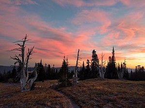
This trail enters the Mt. Hood Wilderness and is a classic Pacific Northwest trail circumnavigating Mt. Hood with alpine vistas, waterfalls, alpine meadows and west side Cascade forest. It was constructed primarily by Civilian Conservation Corps in the 1930s and encircles Mt. Hood at or near treeline. The segment of trail between Timberline Lodge and Yocum Ridge overlaps the Pacific Crest Trail #2000. This trail can be accessed from many different points. The trail climbs in and out of glacial fed drainages throughout its length. Most hikers find the fast moving river fords to be the most challenging part of the trail. Newton, Coe, Muddy Fork, Sandy and White Rivers are typically the most challenging fords but are typically not more than knee deep.
This trail enters the Mount Hood Wilderness Area. The Timberline Trail is a classic Pacific Northwest trail circumnavigating Mount Hood with alpine vistas, waterfalls, alpine meadows and west side Cascade forest. It was constructed primarily by Civilian Conservation Corps in the 1930’s and encircles Mount Hood at or near treeline. The segment of trail between Timberline Lodge and Yocum Ridge overlaps the Pacific Crest Trail #2000. The Timberline Trail itself is 24.5 miles long, but the entire ‘round the mountain trail’ including the PCT is 41.5 miles long. Hike This trail can be accessed from many different points. The trail climbs in and out of glacial fed drainages throughout its length. Most hikers find the fast moving river fords to be the most challenging part of the trail. Newton, Eliot, Coe, Muddy Fork, Sandy and White Rivers are typically the most challenging fords but are typically not more than knee deep.
Check out the Official Route and Triplogs. Leave No Trace and +Add a Triplog after your hike to support this local community. | ||||||||||||||||||||||||||||||||||||||||||||||||||||||||||||||||||||||||||||||||