Route Editor

| Guide | ♦ | 4 Triplogs | 0 Topics |
details | drive | permit | forecast | route |
stats |
photos | triplogs | topics | location |
| 55 | 4 | 0 |
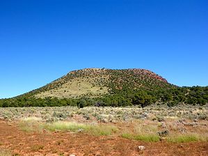
Yet Another "Table Mesa" by kingsnake  Overview OverviewCedar Mountain can be seen soon after you turn west onto AZ-64 in Cameron. Look to your front right, and it is the large, stand-alone, dark mesa in the direction of the Grand Canyon. From the Desert View lookout, look to the east, and it is the large, stand-alone, dark mesa towards Cameron. :-) On satellite view, both its slopes and summit look barren, but that could not be further from the truth: There is quite a bit of vegetation on top, and on the slopes -- except the route this hike follows, which avoids the cliffs which protect most of the summit. Warning The mountain is on federal land, except for the lower half of the east slope on Navajo land. This hike is purely on federal land.
The lady at the Desert View snack bar told my wife that they used to run cattle out at Cedar Mountain, at least up until the 1970s. She said the jeep trail was also a lot better back then. There is an old corral at the base of the west slope. The snack bar lady also said that locals refer to it as "Table Mesa". Hike There is a use trail by the handicap spots: Follow it onto the camping area access road. Proceed through the camping area. Out the back of spot #20 is an old road. (As evidenced by the manholes along its length.) 0.70 mi.: Turn left onto the old jeep trail. It's nice at first, even car drivable. That does not last long. It gets progressively rougher and is soon rutted with drop-offs. Don't think of attempting to drive it without 4WD, high clearance, and skill. But, it is a pleasant walk. As you proceed down the switchbacks -- about 700 feet in the next 1.5 miles -- you will be able to regularly spot the Desert View Tower, Cedar Mountain, Comanche Point, and other points of interest through the trees. Some sections can be exposed, but there is also plenty of shade throughout the day. 3.00 mi.: Right to Cedar Mountain, left to Point Solitude. Signage indicates vehicles are not allowed to turn left. Right is not mentioned. 4.25 mi.: As you break out into a prairie, the jeep trail splits, forming a loop around Cedar Mountain. (Note that the far end of the jeep trail loop is on Navajo land, which is fenced.) Turn left towards the corral. As you approach the corral, turn right towards the clear slope. The route proceeds roughly left-to-right up the slope, towards the low point of the rim. The slope gets steeper as you ascend. You may have to traverse some small rock fields, but no big deal. 5.00 mi.: Cross the rim through a crack in the rock. The summit is just a hundred yards to your left. According to my GPS map, the summit is on a small boulder, but I think it is closer to the rim, a few feet higher. There is a stand-alone dead tree, next to a summit cairn, with a summit log. Enjoy the view, have a snack, enjoy a summit brew and sign the log -- but beware of the incredible winds. Afterward, it is a one-mile loop around the mesa back to the crack, where you will begin your return. The slightly lower east end of the mesa is not nearly as windy. Looping the mesa has great views of the Little Colorado River gorge, Straight Canyon (just north), Cedar Canyon (just south), the Gray Mountains (along which AZ-64 runs), and points far to the east. Hopefully, your day is not hazy because the views are amazing. 6.00 mi.: Back through the crack, down the slope, then back up the jeep trail to Desert View. 11.0 mi.: Choco Taco Time! (They have them at the Desert View snack bar.) Water Sources None. Bone dry. Camping Not sure if it is allowed, but easier to get forgiveness than permission and the views are fantastic. Also, the summit is basically flat, if extremely windy. You might have to anchor your tent to trees, rather than stakes, due to the hard surface. Check out the Official Route and Triplogs. Leave No Trace and +Add a Triplog after your hike to support this local community. | |||||||||||||||||||||||||||||||||||||||||||||||||||||||||||||||||||||||||||