 Route Editor

| Guide | ♦ | 4 Triplogs | 0 Topics |
details | drive | no permit | forecast | route |
stats |
photos | triplogs | topics | location |
| 62 | 4 | 0 |
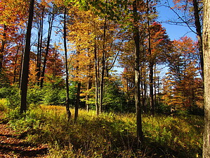
Scenic by HAZ_Hikebot The trail is marked with gray diamonds and is designated MORE DIFFICULT and is best suited to hikers and backpackers. At the Twin Lakes Recreation Area, the trail climbs from Hoffman Run over the plateau and then drops into the headwaters of Wolf Run on its way to South Branch Tionesta Creek. After crossing South Branch Tionesta Creek and then Crane Run, a designated wilderness trout stream, the trail then climbs into the Tionesta Scenic Area.
The trail ends at the North Country National Scenic Trail in the Tionesta Scenic Area. From there, hikers can continue north or south on the North Country National Scenic Trail. Check out the Official Route and Triplogs. Leave No Trace and +Add a Triplog after your hike to support this local community. One-Way Notice This hike is listed as One-Way. When hiking several trails on a single "hike", log it with a generic name that describes the hike. Then link the trails traveled, check out the example. | |||||||||||||||||||||||||||||||||||||||||||||||||||||||||||||||||||||||||


