Route Editor

| Guide | ♦ | 30 Triplogs | 0 Topics |
details | drive | no permit | forecast | route |
stats |
photos | triplogs | topics | location |
| 51 | 30 | 0 |
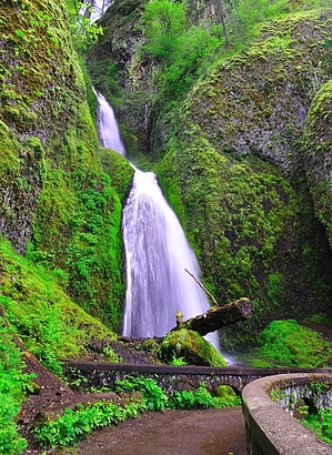
More waterfalls than you can count! by keepmoving  If you enjoy waterfalls, then this trail is for you! It is one of the best trails the Pacific Northwest has to offer and takes you past the tallest waterfall in the state of Oregon, along with countless other waterfalls. Take your camera with you and prepare to have fun! You can hike this loop in whatever direction you choose, but I would highly recommend starting from Wahkeena Falls and hiking counterclockwise (as the following text will describe). I find it easier to take in the beauty of Wahkeena Creek when you are headed uphill and it gives you a good reason to pause and catch your breath. The other nice part about going counterclockwise is that your first view of Multnomah Falls will be looking from the top down. If you have never seen the falls before, it can be quite a surprise to suddenly find yourself standing atop a 600+ foot waterfall looking down on the parking lot far below.
Warning I once read that Multnomah Falls is the most popular hike in Oregon. Driving past the falls on a summer afternoon leaves little doubt in my mind that this is true. However, despite most of the trail being family friendly, there are a couple of narrow rocky sections above Multnomah Falls with significant exposure. In the winter the trail is often slick from rain or fog, and can get icy in some places. If you have young children or dogs, please keep them close as you traverse the narrow sections- hikers have fallen and died in the past. Hike From Wahkeena Falls, head uphill along the paved path and follow the trail as it quickly begins to gain elevation. The trail will soon cut back towards Wahkeena Creek and cross the bridge that you could see from the parking lot. Beyond the bridge, the trail will switchback steeply up the hill for the next half mile before you reach the top of a ridge above Wahkeena Falls. Here, a short walk to your right will take you to Lemmon's Viewpoint, named after a local firefighter that died in a fire. Back on Wahkeena Trail, you will pass a sign marking Monument Viewpoint (closed indefinitely) and the trail will change from asphalt to dirt. The trail now closely follows the creek as it crosses a couple small wooden bridges and works its way up canyon. About a quarter mile from the viewpoint you will encounter a small wooden bench at the base of Fairy Falls. Shortly beyond Fairy Falls you will have the option to turn left onto Viewpoint Trail #419 or continue straight on Wahkeena Trail #420. Both trails will take you to the same place, but Wahkeena Trail will save you about a 1/4 mile and keep you along the creek. Viewpoint Trail is longer, a little steeper in places, and doesn't offer much of a view so I would recommend saving your energy and sticking to Wahkeena Trail. Continuing along Wahkeena Trail past the Viewpoint turnoff, we gain a bit more elevation before leveling out at the junction with Angels Rest Trail #415. Here we turn left and begin the final climb of the loop. But if you need a quick break before the final climb- you could follow the path to the right about 100 yards to Wahkeena Springs for a quick rest at a nice shady spot. Beyond #415, Wahkeena heads steeply uphill for its final climb before depositing you at a nice clearing on a ridge with several trail markers. I have spoken to many hikers at this junction that have asked for directions, but I have never understood what the issue is- the signage seems very clear to me. If have a trail map or read the signs, you really shouldn't have any issues. You simply follow the the signs for Wahkeena Trail #420 towards Multnomah Falls. You will pass Viewpoint Trail on your left, then about 20 yards later you pass Devils Rest Trail on your right. If the trail you are on drops straight down or immediately climb uphill, you have most likely chosen the wrong trail! Wahkeena Trail will very gradually begin to loose elevation as it counters along the hillside and heads towards Multnomah Creek. A bit over a mile past the last junction, you will reach a trail marker telling you have arrived at Larch Mtn Trail #441, turn left here and follow the signs to Multnomah Falls. The trail will gradually lead you closer to the Creek. In short order you will pass Ecola Falls, Weisendanger Falls, and Dutchman Falls. You will then reach a trail marker for Perdition Trail (closed indefinitely) and cross over Multnomah Creek on a small concrete bridge. The trail will head uphill, but you will soon encounter a sign on your left pointing to the Multnomah Falls Overlook. A short 5 minute stroll down this trail and you will find yourself standing on a viewing platform on the edge of Multnomah Falls. When you are done taking in the view, return to the main trail and follow it about 100 feet to the top of the hill. You will pass over the hill and now follow the asphalt path as it switchbacks steeply down the hillside to the base of Multnomah Falls. Once at the base of the falls, follow the left shoulder of the parking lot about 100 yards to the marked sign for the return trail to Wahkeena Falls. In the summer, many hikers try to walk along the roadway between Wahkeena and Multnomah Falls instead of using the return trail. Please do not do this- the road is very narrow with no shoulder and people drive way too fast! Check out the Official Route and Triplogs. Leave No Trace and +Add a Triplog after your hike to support this local community. | |||||||||||||||||||||||||||||||||||||||||||||||||||||||||||||||||||||||||||||||||||||