username
X
password
register
for free!
help
 This is likely a great time to hike this trail!  Check out "Preferred" months below, keep in mind this is an estimate.
 

Wildhorse Lake Trail, OR

Guide 4 Triplogs  0 Topics
  4.7 of 5  
Fav
Wish
0
details
drive
no permit
forecast
route  
stats
photos
triplogs
topics
location
29 4 0
Statistics
tap row or icons for details
Difficulty 2 of 5
Route Finding 1 of 5
Distance Round Trip 2.5 miles
Trailhead Elevation 9,507 feet
Elevation Gain -1,011 feet
Avg Time Round Trip 1.5 - 3 hr
Kokopelli Seeds 7.56
 Backpack Possible - Not Popular
feature photo
Photos Viewed All MineFollowing
15  2018-07-27 Steph_and_Blake
7  2017-06-30 arizona_water
7  2011-08-25 Supden
Author
author avatar Guides 100
Routes 63
Photos 2,548
Trips 184 map ( 820 miles )
Age 76 Male Gender
Location Grand Junction, CO
Associated Areas
list map done
Southeast Region
Historical Weather
Trailhead Forecast
Radar Map
Expand Map
Preferred May, Jun, Aug, Sep
Seasons   Late Spring to Early Autumn
Sun  5:24am - 6:20pm
Official Route & 1 Rt
 
1 Alternative


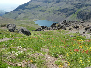
plop down & enjoy a snack
by Steph_and_Blake

 Likely In-Season!
Overview
A moderate hike into a bowl of wildflowers ends at the shores of a clear, pristine lake.


Warning
Nearly all of the hike to the lake is steep and on unstable ground. It took us longer to descend to the lake than it did to get back up to the trailhead.
remove free decal offer
The Hike
From the unsigned trailhead head west down an old Jeep road to the trail register. Sign in and take a left to the rim of Wildhorse Canyon. The trail traverses the canyon wall for a short while before the switchbacks begin. The switchbacks aren’t very steep, but the trail is dusty and/or gravel-laden so the going is slow.

To make up for the tedium of the watching every step, there are an endless number of wildflowers to behold. You might not look up much to see the glistening lake, but you’ll surely stop numerous times to admire the gently swaying sea of reds, blues, pinks, yellows, and whites.

About three-quarters of the way to the lake a couple of small, babbling streams parallel the trail. Here the wildflowers become more varied and abundant. Eventually the trail levels out and within 100 yards you’ll come to the shores of the lake. Plop down, enjoy a snack, and regret not having brought your fishing gear.
0.00072
Return the way you came.

2018-08-01 Steph_and_Blake


    Check out the Official Route and Triplogs.
    Leave No Trace and +Add a Triplog after your hike to support this local community.
    WARNING! Hiking and outdoor related sports can be dangerous. Be responsible and prepare for the trip. Study the area you are entering and plan accordingly. Dress for the current and unexpected weather changes. Take plenty of water. Never go alone. Make an itinerary with your plan(s), route(s), destination(s) and expected return time. Give your itinerary to trusted family and/or friends.

     Permit $$
    None


     Directions
    or
     Road
    FR / Dirt Road / Gravel - Car Okay

    To hike
    From Frenchglen, Oregon:

    Take OR-205 South. Turn left onto Steens Mountain Loop Road. Drive approximately 27 miles. Follow signs to Wildhorse Lake.
    page created by HAZ_Hikebot on Aug 01 2018 12:06 pm
     90+° 8am - 6pm kills
    helpcorrectionissue

    end of page marker