 Route Editor

| Guide | ♦ | 5 Triplogs | 0 Topics |
details | drive | permit | forecast | route |
stats |
photos | triplogs | topics | location |
| 19 | 5 | 0 |
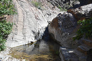
The creek that disappears by markthurman53  The Rio Grande River comes down out of Colorado heads south through New Mexico and passes through El Paso, Texas where it now becomes the border between the United States and Mexico. The river flows 1254 miles in a South East direction toward the Gulf of Mexico but before getting there it makes a turn to the North East, creating a momentary bend in the river, This Is Big Bend National Park. The mountains in this park are a continuation of a mountain range in Mexico which will continue up into the US through Guadalupe National Park and into New Mexico. The highest Point in this park is Emory Peak at 7800 feet. This park is probably one of the remotest parks in the contiguous United States but despite being in the middle of nowhere has a lot to offer in hiking, camping and general sightseeing. WINDOW TRAIL
The Window Trail is a short 2.1 miles one way hike down Oak Canyon to an approximately 200 foot drop off where the trail ends and the creek disappears. This is a must do trail especially if you only have a short stay in the park. The trail is an Easy and well maintained trail with built in concrete rock stairs in the inner canyon to assist in areas where the canyon gets narrow. As you get deeper into Oak Canyon it is like you are walking along a crack in the earth with steep and sometimes sheer cliffs on either side. Even the sun spends little time in any one place very long, except in summer when I bet it beats down in this gorge and I would be willing to bet even at night. The trail ends abruptly at a narrow in the canyon at a drop off. There is nowhere to go but back the way you came. This is an Awe inspiring and even a little unnerving vista. A word of caution the rocks are polished and very slick near the drop off and to make matters worse, wet, I stayed back quite a bit and just imagined what the drop off looks like. The other caution is to be aware of the weather, you do not want to do this trail if there is a chance of rain. A flash flood would be a very bad thing if you are in the inner canyon. Description There are a couple options as to where to start this trail, either the visitor Center or at the Basin Campground. This description is from the the far west side of the Basin Campground, starting from the Visitor center adds a couple tenths of a mile. The first 1.5 miles is a gradual downhill slope as you descend down the lower inner basin to Oak Creek. This portion of the trail is through Oak, Mesquite and Juniper trees with a sprinkling of agave plants along the way. In May these agave are flowering with their tall shafts that will be their life’s epitaph. To the west along this trail is Carter Peak and Vernon Bailey peak that tower over on either side of Oak Canyon. Once you enter Oak Creek, the trail gets really interesting. The canyon narrows and now the only views are in the canyon immediately in front or in back of you and the steep hills and cliffs that are on either side. From this point on the trail follows Oak Creek with its many small pools of water and rock obstructions. In the areas where the rock appears to block the way or make it harder to navigate there are built in steps that assist the hiker and actually make it quite easy to traverse. This section was quite interesting with something fascinating around each bend. After about a half mile along this section the trail ends where the canyon in front of you disappears over a drop off. Very impressive view off to the west over a section of canyon that disappears just a couple of feet in front of you and two shear rock walls on either side just 10 feet apart. The rocks near the drop off are very polished and slick. They were wet too, making it even more dangerous. I enjoyed the experience from a safe 10 feet back. I have hiked many of the trails in the Chisos Mountains. None left the impression like this standing over the drop off. Check out the Official Route and Triplogs. Leave No Trace and +Add a Triplog after your hike to support this local community. One-Way Notice This hike is listed as One-Way. When hiking several trails on a single "hike", log it with a generic name that describes the hike. Then link the trails traveled, check out the example. | |||||||||||||||||||||||||||||||||||||||||||||||||||||||||||||||||||||||||||||||||||||||||


