 Route Editor

| Guide | 0 Triplogs | 0 Topics |
details | drive | permit | forecast | map |
stats |
photos | triplogs | topics | location |
| 10 | 0 | 0 |
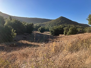
Recluse in the Reserve by mt98dew The Santa Rosa Plateau Ecological Reserve (SRPE) is a small oasis in the sprawling network of California inland cities. Located between Murrieta and Lake Elsinore it provides nearby residents with the opportunity to hike and bike without the concrete and backyards that dominate much of their landscape. The Reserve also has some historical significance. There is evidence of tribal activity dating back to the 1100 and, more recently, the Reserve has the two oldest standing structures in Riverside County dating back to 1846. In addition to being a retreat from city life, the Reserve provides a crucial habitat for over 200 species of animals, 49 of which are endangered. It also has a diverse range of climes: including riparian wetlands, grasslands, coastal sagebrush, oak woodlands, and chaparral. Many of these habitats have been compromised in other locale, and this Reserve plays an important role in preserving an ecosystem necessary for supporting an array of wildlife.
Hike The Punta Mesa is an interior trail so some additional hiking is required. Hiking from the visitor center you have several options on how to reach it. Going in a clockwise direction, follow Waterline Rd for 0.8 miles and then turn right (south) onto Vista Grande Trail. This will be a signed transition going from a road to a trail. (Not much difference between the two, except the trail is smaller in width). Follow the Vista Grande Trail for 0.7 miles where it intersects the Monument Hill Rd. Turn left (east) onto Monument Hill and follow for 0.2 miles to reach the beginning of the Punta Mesa Trail. The Punta Mesa Trail begins in a basin surrounded by low-lying hills covered in native bunchgrass with oak trees dotting the slopes. The trail starts off heading south and quickly tops a small saddle. The trail then descends into a small valley with hills rising on either side. As you drop down into the valley the hills will rise on either side of you, the trail will stay near the base of the western slope. The growth becomes thicker as you descend and as you near the bottom, you’ll have a couple of brief sections where you pass through a copse of trees. Around 0.5 miles, while still descending, the trail will have intermittent sections of flatness, and eventually, the southern slope will gradually drop off so it feels like you're hiking on the side of the hill. At 1.3 miles the trail comes to a bridge and crosses over a dry creek. Initially, the trail is fairly smooth, composed of compact dirt, but after it crosses the bridge and begins to climb the trail becomes rocky and rutted. Around 1.45 miles the the trail does a couple of switchbacks as it climbs out of the canyon. There are some decent-sized brush and trees as you climb, nice for shade, but bad for views. However, the few glimpses of the surrounding valley should be enjoyed, because once you reach the saddle the trail ends at 1.9 miles under a thick canopy of trees. At this point, you have a multitude of options. You can return the way you came for about a 4-mile in-and-out hike or you can continue on the Adobe Loop Trail and connect to other trails in the area. All the trails are signed but there are not many maps of the area, so plan accordingly. Take a picture of the map at the visitor center or be aware of what trails lead back to the TH. Synopsis The Punta Mesa Trail is one of the more removed trails in the preserve. It takes a little more hiking to get to this trail, but it will keep you away from most of the masses and provide a secluded commune with the California climes. The views won’t astound but the simple solitude that comes with this hike makes it one of the noteworthy trails in the Santa Rosa Plateau Ecological Reserve. Leave No Trace and +Add a Triplog after your hike to support this local community. One-Way Notice This hike is listed as One-Way. When hiking several trails on a single "hike", log it with a generic name that describes the hike. Then link the trails traveled, check out the example. | ||||||||||||||||||||||||||||||||||||||||||||||||||||||||||||||||||||||


