This beautiful and challenging single-track trail is located in the Trabuco District and is easily-accessible from Orange and Riverside Counties. A popular trail with mountain bikers, be prepared for a very strenuous ride as extreme exposure and brutal climbing through switchbacks for the first several miles means this trail is not for beginners. For those adventurous enough to endure the climb, the views from the top make the effort well worth it. With heavy bike activity on weekends and holidays, hikers are asked to be alert and observant. Bikers are asked to keep a moderate pace downhill anticipating hiker use.
It should be noted that cell coverage is almost non-existent on the trail, and the 11 mile trip (one way) means that trail users should be prepared with extra supplies and water. On mild days, it is easily possible to go through 4 liters (1 gal) of water per person in less than two hours. Parking permits are required, and can be purchased locally.
When hiking several trails on a single "hike", log it with a generic name that describes the hike. Then link the trails traveled, check out the example.
WARNING! Hiking and outdoor related sports can be dangerous. Be responsible and prepare for the trip. Study the area you are entering and plan accordingly. Dress for the current and unexpected weather changes. Take plenty of water. Never go alone. Make an itinerary with your plan(s), route(s), destination(s) and expected return time. Give your itinerary to trusted family and/or friends.
Permit $$
no fees or permits reported
if incorrect tell us about it
Cleveland Forest An Adventure Pass is needed when parking at any TH located in the Cleveland NF.
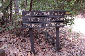
To hike The lower trailhead is in Hot Spring Canyon 3/4 mile past the San Juan Fire Station. The upper trailhead is at Blue Jay Campground 4 miles north of the Ortega Highway on Long Canyon Road.
page created by HAZ_Hikebot on Mar 09 2010 11:31 pm
 Route Editor


