Route Editor

| Guide | ♦ | 1 Triplog | 0 Topics |
details | drive | permit | forecast | route |
stats |
photos | triplog | topics | location |
| 39 | 1 | 0 |
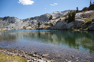
More lakes than you can shake a stick at by slegal For a hike that to me seemed quite out of the way, this can be a very busy place. In fact, we had to park so far down the road from the trailhead that we tacked on close to an additional six-tenths of a mile to our hike.
We opted to do the full hike, which meant that because of the extra mileage from the far away parking, our hike was about 9.3 miles. This means a 4 mile trek around Saddlebag Lake, marking the beginning and end of the hike. We also did probably an extra quarter mile of extracurricular hiking. Therefore, the official distance of the while loop should probably be about 8.5 miles. Note that the west side of Saddlebag Lake is much shorter than the east side. The trade off is that the east side is more scenic and less rocky than the west side. The recommended direction to take on the loop is counter clockwise. The reason is that there is a steep loose hill just south of Lake Helen and that hill is much better suited for going downhill than uphill. We opted to do a figure 8 that had us go up that steep loose hill. How you go is your choice. The hike passes 9 named lakes and a number of streams with larger pond areas. The views at many of these lakes are stunning, so don't forget your camera. A short detour from the main trail will take you to several other lakes including the Cascade Lakes that are located just west of Steelhead Lakes and the Twin Lakes and Z Lake located in the middle of the loop. Several other lakes can be found higher up on the slopes surrounding the basin. Check out the Official Route and Triplog. Leave No Trace and +Add a Triplog after your hike to support this local community. | |||||||||||||||||||||||||||||||||||||||||||||||||||||||||||||||||||||||||||||||||||||||||