 Route Editor

| Guide | ♦ | 122 Triplogs | 10 Topics |
details | drive | permit | forecast | 🔥 route |
stats |
photos | triplogs | topics | location |
| 846 | 122 | 10 |
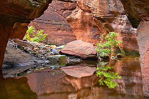
unexpected change by Kip   Overview OverviewOn the hike, you go through wide-open spaces, small pines, big pines, oaks, ferns, wildflowers, and red-rock canyons! 0 mile Trailhead 1.9 miles David Miller 2.0 miles Canyon wall views 2.3 miles Good camping 2.9 miles Narrows
If you're into filtering brown, stagnant water, there were pockets on this trip. If not, bring water. The trail is well maintained and easy to follow. For the most part, the hike is flat. There are a few ups and downs through ravines. Nothing serious. I'm sure with a pack, it might drain you after a while. Maybe it's me, but it felt hotter than forecasted during the day and cooler than forecasted during the night. This is especially true when you are in the wide-open areas without shade. I'm not sure I would do this hike with a pack any later than May. A couple of good campsites become available around 2.3 miles. There's a great spot with a clear view of the canyon wall, 34 57.256, -111 51.235. This is one of the few places where you see the canyon walls without trees in the way. If you want to hike further in, there is a worthy spot just after the waterfall too 34 57.391, -111 52.004. Although there is occasional airplane noise, this is the quietest place I've camped in a long time. In mid-May, on this trip, at least, the hike provided great photo opportunities for wildflowers, butterflies, and your typical Sedona red canyons. If there's no water, the waterfall is still a good photo opportunity; it gives you the curvy rock/slot canyon picture. Behind the waterfall campsite mentioned above, it's possible to get up on some red rocks and get above the trees: Scramble up the wooded hill until you run into the red rocks; from there, walk around until you can find a safe place to get up. I'm not a plant guy, but after reading Joe's warning, I did come across several plants that could pass for poison ivy. The plants were around the river crossings, on stalks about knee-high, had three, spear-shaped leaves, and a number of the leaves were shiny and turning red. If you're not familiar with poison ivy, it can be real nasty stuff; take a few minutes to read up on it.
Coconino FS Details The Secret Canyon Trail is of moderate length, leading into the Wilderness. The first two miles follows an old road bed, that is fairly flat and easy going. The rest of the way, the trail meanders in and out of the canyon bottom. Vegetation varies from chaparral to mixed conifer along this typically dry water course. The signed trailhead is across the usually dry streambed of Dry Creek west of the parking area. The trail immediately enters Wilderness. The wide, nearly flat trail leads into the wide canyon mouth with nice views, but no shade from the desert scrub vegetation. At 2/3 mile, HS Canyon Trail branches off to the left. Continue ahead for Secret Canyon. At 2 miles, continue ahead (west) as the trail drops down to cross a drainage. It climbs gently for the next 3 miles beside the canyon drainage, frequently dipping down to cross it. There is shade from oak and ponderosa and nice views of red rock formations. At 5 miles, the streambed turns sharply left a short distance to an interesting "chute". Return to the trail which continues ahead, climbs sharply, then levels out. At 5.5 miles, there is a deep ravine and a series of pools in the solid rock streambed. An unmaintained trail continues on. Return by the same route for an 11 mile hike. The hike can be shortened and still be worthwhile. The trail can be very hot in summer. Check out the Official Route and Triplogs. Leave No Trace and +Add a Triplog after your hike to support this local community. | ||||||||||||||||||||||||||||||||||||||||||||||||||||||||||||||||||||||||||||||||||||||||||||||||||||||||||||||||||||||||||||||||||||||||||||||||||||||||||||||||||||||||||||||||||||||||||||||||||||||||||||||||||||||||||||||||||


