Route Editor

| Guide | 0 Triplogs | 0 Topics |
details | drive | no permit | forecast | route |
stats |
photos | triplogs | topics | location |
| 2 | 0 | 0 |
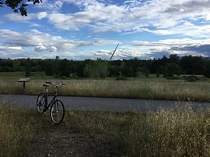
A Paved Escape by lojones5  The Arboretum Perimeter trail is a 1.4 mile loop that can be found just past the popular Sundial Bridge, across a much smaller bridge that crosses over Sulphur Creek. It can also be accessed from a steep paved trail down from Hilltop. This short loop trail is less traveled than the Sacramento River Trail that follows the river, and is usually a bit of an escape from the more populated areas around Sundial Bridge. Warning Watch out for rattlesnakes.
The hike is paved the entire way, but there are a couple areas with small hills so I don't think it'd be considered wheelchair accessible. The loop makes for a nice bike ride or hike, and has a bench at the halfway point under a nice tree with a view across a field toward the Sundial Bridge. It is common to spot deer along this hike, so keep an eye out for them. Water Sources Water can be found at the Arboretum entrance which can be seen from the North side of the Sundial bridge. Check out the Official Route. Leave No Trace and +Add a Triplog after your hike to support this local community. | ||||||||||||||||||||||||||||||||||||||||||||||||||||||||||||||||||||||||||||||||||