Route Editor

| Guide | ♦ | 4 Triplogs | 0 Topics |
details | drive | no permit | forecast | route |
stats |
photos | triplogs | topics | location |
| 46 | 4 | 0 |
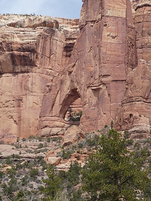
 Located west of The Comb and near the Abajo Mountains is Arch Canyon. So named for three arches at the end of the drive/hike. The drive came highly recommended by two outdoor guides out of Blanding. Warning If driving, this route requires a high-clearance 4x4 vehicle and some off-road driving skills. There are at least two sections that a driver benefits from a spotter and one place (over a big tree root) that might warrant road-building. There are a couple sandy sections that one shouldn't dally in and countless stream crossings (if it's wetter than when we were there). Airing down the tires is a good decision. Be on the lookout for oncoming traffic and be mindful of areas in which you could pull over. Backing up for oncoming traffic will be slow and tight.
The one lane "road" starts out crossing the stream and then you're engulfed in 8-foot high reeds and shrubs. It's not a very compelling beginning, especially if you're concerned about unseen vehicles coming towards you from the other direction. However, not more than a half a mile into it there is a large parking area for Arch Canyon Ruins. These dwellings are particularly interesting in that they were up to 4 stories tall and they are of both Chacoan and Mesa Verde construction styles. The glyphs are also notable for many near-perfect spirals across the back of the alcove. After leaving the Ruins, the view starts to open up and gradually builds to soaring sandstone cliffs, fins, spires, and alcoves. If you're not driving, keep scanning the right-hand side for deep recesses. You don't know what you might see! The walls are reminiscent of Canyonlands and, in particular, hiking in The Maze District. About 5 miles in, if we're to be honest, the drive gets to be a bit tedious. As in, how much longer before we see the arches?? Eventually, it ends rather abruptly at a nice camping area amid Ponderosa Pine replete with a sturdy picnic table. From here you can see Cathedral Arch. To view the other two arches one must take to foot. We had a late-late lunch and decided to forego the hiking as we knew it would be another couple of hours to get back to the trailhead, air-up the tires, and then another hour to camp. Check out the Official Route and Triplogs. Leave No Trace and +Add a Triplog after your 4x4 trip to support this local community. | |||||||||||||||||||||||||||||||||||||||||||||||||||||||||||||||||||||||||||||||