Route Editor

| Guide | ♦ | 3 Triplogs | 0 Topics |
details | drive | permit | forecast | route |
stats |
photos | triplogs | topics | location |
| 14 | 3 | 0 |
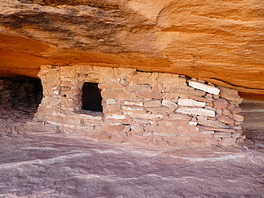
slick friction by Steph_and_Blake  A moderate hike to atop two prominent buttes with ruins constructed by ancestral Puebloans. Warning There is some exposure on the first (smaller) butte to reach the granaries. It wouldn't likely be fatal if you lost your balance and slipped, but it might make some feel uncomfortable to make the move. To reach the second butte requires some scrambling over steep slickrock that, again, might make some hikers unaccustomed to Utah terrain uncomfortable.
At the parking lot, take a moment to review the posted sign about the sites and proper etiquette. From there, follow the well-worn path over to the first butte. You actually end up going around the back-side of the butte and then taking a hard left at the "T" to scramble up to the top. Once on top you'll see a path going to the rim on the north side. A short scramble down a narrow "crack" in the rock brings you to the bench below the rim. Here you'll find a short section of small exposure, but you'll be rewarded with an up-close look at two well-preserved granaries. To our knowledge there are no more ruins or "interesting things to see" on the first butte, but you might explore back up top. When you're finished with the first butte, head down the same route you took to get to the top and pick back up the trail at the "T". Continue northeast to the base of the second butte, formally known as Aztec Butte. There is no defined trail across the slickrock, but there are plenty of cairns to guide you to the top. A couple times you'll be on all fours, trying to lower your center of gravity over the steep portions. You might also want to do some partner-assists to help each other get up some more challenging climbs. Once on top of the rim there's a path to follow that hugs the edge. To be honest, we didn't see any ruins on Aztec Butte that looked bona-fide (i.e. no mortar on the walls of supposed granaries) and the one structure to the south just didn't look, to us, like ancient construction. I spoke later to a ranger at Arches about this. He wondered if they'd been taken down during an excavation and then put back together again without mortar. Anyway, the views from up top were great. Once done exploring and checking out the many alcoves under the rim, make your way back to the point where you topped out. Climb down over the rim and say "thank you" to the slickrock for its much-appreciated friction while you make your way to the bottom. Retrace your steps to the parking lot.
Check out the Official Route and Triplogs. Leave No Trace and +Add a Triplog after your hike to support this local community. | ||||||||||||||||||||||||||||||||||||||||||||||||||||||||||||||||||||||||||||||||||||||||