Route Editor

| Guide | ♦ | 8 Triplogs | 2 Topics |
details | drive | permit | forecast | 🔥 route |
stats |
photos | triplogs | topics | location |
| 67 | 8 | 2 |
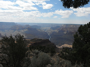
Not as flat as a pancake! by azbackpackr  General information and history General information and historyThe Powell Plateau is a large mesa semi-detached from the North Rim by a neck of land, sort of like a peninsula partially surrounded by deep side-canyons. Over much of its 8.5 square mile surface, it’s relatively flat and covered with a fine forest of Ponderosa Pines. At an elevation of approximately 7400 feet, the best time to visit is summer. There is a great deal of history and prehistory associated with this area, starting with the Anasazi, who lived on its top during the 11th and 12th centuries. Much later on, in 1870, John Wesley Powell visited the plateau that now bears his name. In 1873 he returned, bringing along an artist, Thomas Moran, whose famous painting Chasm of the Colorado is a compilation of views, including the panorama from Dutton Point on Powell Plateau. This painting hung in the US Senate for many years. It now is found in the Smithsonian American Art Museum. However, now that I’ve been to Dutton Point, I don’t see much of a resemblance to the painting! In the early 1900s, Theodore Roosevelt hunted mountain lions on the Plateau, as did Western author Zane Grey, both unwittingly contributing to the infamous ecological disruption of that area. Between 1907 and 1939, virtually all predators were removed from the Kaibab Plateau, mostly by the US government, causing the deer population to explode, creating deer starvation and habitat destruction. wiki
The hike The hike begins at Swamp Point. The trailhead is the same as for North Bass Trail. When reaching Muav Saddle, watch for a turn to the right, which leads to the ranger cabin, also known as “Teddy’s Cabin”, although it was not built until 1925, so Roosevelt didn't stay there. A hard left turn after that would take you down the North Bass Trail. So, you want to take the first right turn, visit the cabin, then retrace your steps back to the main trail, and go straight at the junction with North Bass Trail, which goes left. There are no signs. It’s pretty clear where the trails lead, however. You can see North Bass Trail snaking down the hillside into White Canyon, and you can also see the Powell Plateau and the direction you must take to get there. It would be pretty hard to get lost, especially if you have a map. Reaching the rim of the Plateau, it flattens out immediately. There is a metal cabinet at the first flat area which holds fire tools and empty water containers. From here, a well-traveled trail leads south, generally following the east rim of the Plateau. After a couple of miles, the trail becomes very faint in places or is covered with deadfall. However, careful route-finding will allow a hiker to follow this trail almost all the way to Dutton Canyon, at which point I could no longer find any trace of it. This trail was built in the 1920s but has not been maintained. To reach the famous Dutton Point, named after the geologist Clarence Dutton, it is necessary to cross Dutton Canyon. This is not dangerous, just slow-going through the thorny brush. Several other canyons may be encountered by the hiker, especially if straying too far to the west. After crossing Dutton Canyon, I used a GPS to mark Dutton Point, making it easier for me to find it. Several points overlook the Canyon, and any one of them will afford a fine view worth taking time to see. However, you can't see the Colorado River until you reach Dutton Point. You may also find traces of the old trail along this rim, but it’s not reliable on the south side of Dutton Canyon. When leaving Dutton Point, keep more or less to the east side of the plateau the way you came in. If you think you will find a better place to cross Dutton Canyon toward the west, you'll be mistaken. When bearing west-northwest, I encountered not one but four thorny canyons to cross! It was an error in judgment I won't make again if I return to the area. Permits and logistics Although at this writing, the road to Swamp Point can be reached without putting your vehicle into 4 wheel drive mode, it’s still preferable to use a 4WD to get there. If it should rain, you'll need 4WD to get out of there! If you plan to day hike to the Plateau, you can get a car camping permit from the Backcountry Office, same as you would get a backpacking permit. Of course, since the Plateau is in Grand Canyon National Park, you will need a permit if you want to overnight backpack. The rangers do stop by. While I was solo hiking the Plateau, my companion was visited by rangers at our camp, asking to see our permit. Check out the Official Route and Triplogs. Leave No Trace and +Add a Triplog after your hike to support this local community. | ||||||||||||||||||||||||||||||||||||||||||||||||||||||||||||||||||||||||||||||||||||||||||||||||||||||||||||||