 Route Editor

| Guide | ♦ | 1 Triplog | 0 Topics |
details | drive | no permit | forecast | route |
stats |
photos | triplog | topics | location |
| 9 | 1 | 0 |
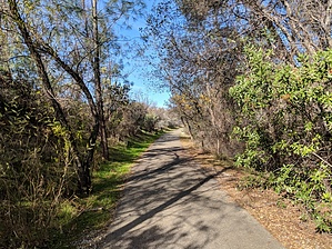
Only City Owned Gold Mine by lojones5  The Blue Gravel Mine Trail follows alongside Buenaventura Blvd., but far enough away from the street in local woodlands. The trail paves through a small canyon by a seasonal creek, and passes the historic Blue Gravel Mine. The trail offers some shade, and is paved the entire way. In the Springtime the trail has many wildflowers and butterflies to enjoy. The Holiday Market shopping center is located at the North end of the trail, and includes some shopping and restaurants. Warning Watch out for rattlesnakes and bikers. Dogs are only allowed on leash.
For $8,500, the City of Redding purchased 451 acres of land in the year 1927. The Blue Gravel gold mine was included in this purchase, and was the only gold mine in the United States that was owned by a city. It got its name from the blue gravel waste site near the mill. Hike The hike follows a paved asphalt path through a canyon and near Beuanaventura Blvd. The walk provides shade from the canyon and the many trees along the route. Check out the Official Route and Triplog. Leave No Trace and +Add a Triplog after your hike to support this local community. One-Way Notice This hike is listed as One-Way. When hiking several trails on a single "hike", log it with a generic name that describes the hike. Then link the trails traveled, check out the example. | |||||||||||||||||||||||||||||||||||||||||||||||||||||||||||||||||||||||||||||||||||||


