Route Editor

| Guide | ♦ | 6 Triplogs | 0 Topics |
details | drive | no permit | forecast | map |
stats |
photos | triplogs | topics | location |
| 124 | 6 | 0 |
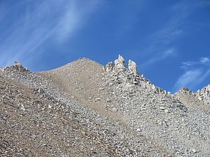
Push your Boundarys by DixieFlyer At an elevation of 13,140 feet, Boundary Peak is the highpoint for the state of Nevada. As its name implies, Boundary Peak is near a boundary -- in this case the California-Nevada border. Boundary is about 1/4 mile from California and is about 0.6 miles from Montgomery Peak, which is in California and is about 300' higher than Boundary Peak. In fact, with only 253 feet of topographic prominence, Boundary Peak is often considered a sub-peak of Montgomery Peak.
Hike This is a fun hike that is a mixture of class 1 and class 2 hiking, with a little boulder scrambling as you near the summit of Boundary Peak. There are two different trailheads that you can take to get to Boundary Peak: Queen Canyon TH and Trail Canyon TH. The statistics in this guide assume a start from the Trail Canyon TH. Trail Canyon Route The trailhead is at about 8,900 feet of elevation. The first 1.5 miles or so of the hike is along a forest service trail on the south side of Trail Canyon. As of August 2020, the trail is a bit overgrown but wasn't too difficult to follow. You will make a couple of crossings of a small stream that is not too far from the trailhead, but you shouldn't have any difficulty keeping your feet dry. The trail system ends at a meadow at about 9,800 feet of elevation. Once you get to the meadow, the trail will continue northwest to your left -- however, this will take you to the "descent route" (more on that later). Instead, continue to the right of this "trail", and head due west up to Trail Canyon Saddle. While this is off-trail, you'll mostly encounter small bushes less than knee-high, and there are some game trails and social trails that you can follow. It is not as easy as following a well-groomed trail, but it is easy as far as bush-whacking goes. You'll continue to the west until you get to Trail Canyon Saddle, which is at about 10,800 feet. From Trail Canyon Saddle, you'll head south towards an unnamed peak at an elevation of 12,200 feet. Rather than going to the top of this peak, you'll skirt the west side of it to a saddle. This is a steep climb on loose dirt and scree -- it is not too bad to ascend, but don't plan on setting any speed records. From the saddle continue on an easy-to-follow trail until you get the start of some boulder fields. Once at the boulders, you'll mostly be following a ridgeline on the boulders until you get to Boundary Peak, although for the most part, you will be to the right of the ridgeline. There are some cairns here-and-there on the route, and you can often see use trails that others have followed. However, don't be afraid to use your own judgment as to picking a route -- there is no real exposure along the way, so you won't likely get into any trouble. There are some really nice 360 degree views at the summit. The view takes in the Mono Lake basin to the north, the Sierra Nevada Mountains to the west, the White Mountains Wilderness to the south, and Nevada’s Basin and Range to the eastern horizon. You can also see Montgomery Peak 0.6 miles away. When leaving, return the way you came through the boulders section of the hike. Once past the boulders, you will come to a saddle. At this saddle is a "descent route" that goes down to your right through the northeast drainage of the peak. While the descent route is steep --you'll drop about 1,600 feet in 3/4 mile -- you are on sandy terrain that is akin to being at a beach. As such, with the use of trekking poles, it is not a difficult descent. Note that you'd be crazy not to use trekking poles on this descent though. If you don't want to follow the "descent route", then just return to the trailhead the way that you came up. Note that it will be a slippery descent on scree as you make your way back to Trail Canyon Saddle. Queen Canyon Route If you are able to drive all the way to the 4WD trailhead for Queen Canyon, the hike will be about a mile shorter with 900 feet less elevation gain as compared to starting from the Trail Canyon TH. The Queen Canyon route follows a well-defined use trail, ascending south and west to the ridgeline overlooking Trail Canyon. The route continues along the south side of the ridgeline to Trail Canyon Saddle. From Trail Canyon saddle, the route to Boundary Peak is the same as for the Trail Canyon route. Return the way that you came back to the trailhead. Note that on the way back you WILL NOT be taking the descent route to the Trail Canyon TH. Those taking the Queen Canyon route may wish to review the triplogs of others who have taken this route. Synopsis This is a fun hike, but it is best undertaken by experienced hikers who have solid route-finding and cross-country navigation skills. Check out the Triplogs. Note This is a moderately difficult hike. Leave No Trace and +Add a Triplog after your hike to support this local community. | |||||||||||||||||||||||||||||||||||||||||||||||||||||||||||||||||||||||||||||||||||||||||||||||||||||