Route Editor

| Guide | ♦ | 1 Triplog | 0 Topics |
details | drive | permit | forecast | route |
stats |
photos | triplog | topics | location |
| 6 | 1 | 0 |
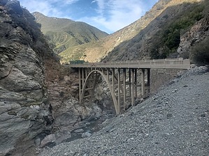
Come for the bungee jumping, stay for the artwork by ShatteredArm A popular hike in the lower reaches of the San Gabriel Mountains featuring steep canyons and the remains of a very ill-fated transportation project. History In the 1930s, the government undertook a project to create a shorter route to Wrightwood, CA, and began construction on a road up the East Fork of the San Gabriel River. Several miles of construction had been completed, when in 1938, a major flood washed out several parts of the road, and the project was abandoned in favor of the current alignment up to Islip Saddle, farther west. A road bridge survived the flood, however, and remains to this day as part of a private inholding located in the middle of what is now the Sheep Mountain Wilderness.
The hike begins at the East Fork trailhead at the end of East Fork Road. Because it is a popular trail, the parking area fills up early; additional parking can be found a half mile or so down the road. The hike starts out along the old road grade and generally follows it whenever feasible. About a half mile in, you reach the junction of the Heaton Flat Trail (which climbs steeply out of the canyon), which is a nice camping area for the homeless. The first of several creek crossings (there may or may not be water in the creek) is a little under a mile in, after which the existence of road grade becomes a little less consistent. At the second crossing, after about a mile and a quarter, the remains of a washed-out bridge can be seen. There's quite a bit of graffiti up to this point, but it starts to die out - although there are still tags miles in, so one has to admire the dedication of these fledgling artists. Generally, the route finding is straightforward, although there are a couple of areas where you can get off the main trail. In most of these cases, it's no big deal. A little over three miles in, you might see a road grade and go up to it - in this particular case it isn't passable, but you'll get a pretty good idea why the road project was abandoned. Over 3.5 miles in, after the big washout, the trail does join the road grade for good - if you have gone four miles and you're not on the road, you missed the turn. The road gradually climbs away from the riverbed, providing some nice views. At about 4.5 miles in, you'll reach the private property inholding, where you're asked to stay on the trail. Before long, you reach the bridge, where you can hang out, proceed past down to the creek, or do some bungee jumping if you're so inclined (provided they're open for business). The trail officially ends just past the bridge, but you can explore farther up the San Gabriel River if you're feeling adventurous. It is also possible to do a point-to-point shuttle from higher up the canyon, starting from Cabin Flat or Vincent Gap. Water Sources The East Fork is often dry, but may have flow some parts of the year. It can also flood during heavy rainfall, making the crossings dangerous. Camping Camping along the East Fork trail is not popular, except in the Heaton Flat area, which appears to be used as a homeless camp. Note A California Adventure Pass is required to park in this part of the Angeles National Forest. These can be purchased in Camp Williams and Azusa, and passes such as the Access Pass and Interagency Pass are valid. Check out the Official Route and Triplog. Leave No Trace and +Add a Triplog after your hike to support this local community. | ||||||||||||||||||||||||||||||||||||||||||||||||||||||||||||||||||||||||||||||||||||||||||||||||