 Route Editor

| Guide | ♦ | 16 Triplogs | 0 Topics |
details | drive | permit | forecast | route |
stats |
photos | triplogs | topics | location |
| 93 | 16 | 0 |
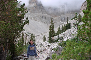
This is Nevada? by rally_toad Warning The trailhead is at almost 10,000 feet, and you will be climbing at least 600 feet to the Bristlecones, 1100 if you plan to make it to the Glacier. Be prepared and know your limits. Remember the only cure for altitude sickness is to go to a lower elevation as soon as possible.
Start from the trailhead at the end of the Wheeler Peak Scenic Drive. Cross the bridge and turn right for the Bristlecone-Glacier, and Alpine Lakes trails. The trail ascends gradually through an Engelmann spruce forest. Before too long you will come to another junction for the Alpine Lakes Loop. Turn left to stay on track for the Bristlecones. The trail continues through some pretty forest, look around and you might be lucky enough to see and hear Clark's Nutcrackers flying through the trees. At 0.7 miles you come to another trail junction for the Alpine Lakes Loop and Theresa Lake, continue left towards the Bristlecones. As you continue your ascent, the trail and the terrain around you gradually become rockier. As you climb, the spruce appears less frequently, and the trees are more spread out. You will now be seeing primarily Limber Pines and Bristlecone Pines from here on out. Keep an eye out on the left-hand side for a little-known lake, Brown Lake, a couple hundred yards off the trail. Brown Lake is the only lake in the park that is located in a Bristlecone grove and has many Bristlecones around it. Continue hiking up the now rocky trail until you come to a sign marking the Bristlecone interpretive loop. This trail is very short and worth your time. Interpretive signs explain the scientific significance of the Bristlecones and how they are dated. They also have put signs under some of the trees that they have aged, the oldest one marked on the trail is 3200 years old, and it doesn't look like it's going anywhere anytime soon. In season there may be a Park Ranger at the grove to answer questions and conduct guided walks along the loop trail. After you complete the interpretive loop, follow the signs for the Glacier and turn left at the junction. Continue into the Wheeler Peak cirque and soon you will find fantastic views of the peak, and depending on the time of year either snowfields or the Glacier itself. You will have to remind yourself that you are indeed in Nevada and not Colorado or Montana. This is one of the most beautiful areas in the park in my opinion. The trail will cross snowfields for all but a few weeks of the year, try your best to stay on the trail, as the alpine life is delicate. The trail ends at a sign that proclaims "Rock Glacier 10,800 feet". Enjoy the views of the peak, glacier, bristlecone grove, snake valley, and other parts of the snake range. This is a good place for lunch, but be advised early or late season hikers might find the cirque area cold and very windy. When you are ready turn around and head back the way you came. Enjoy the rest of the park! Check out the Official Route and Triplogs. Leave No Trace and +Add a Triplog after your hike to support this local community. One-Way Notice This hike is listed as One-Way. When hiking several trails on a single "hike", log it with a generic name that describes the hike. Then link the trails traveled, check out the example. | |||||||||||||||||||||||||||||||||||||||||||||||||||||||||||||||||||||||||||||||||||||||||||||||||||||||||||||||||||||||||||||||||||||||||||||||||||||||||||||||||||||||||||||


