Route Editor

| Guide | ♦ | 2 Triplogs | 0 Topics |
details | drive | no permit | forecast | route |
stats |
photos | triplogs | topics | location |
| 15 | 2 | 0 |
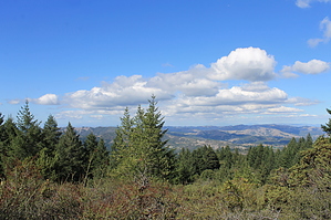
Good Workout With Redwoods and Views by JimmyLyding  This hike starts at the dam for Alpine Lake in the Marin Municipal Water District holding on the north side of Mount Tamalpais. There are at least 2 dozen parking spots between the dam and the actual trail head 1/4 mile south on the Bolinas Road between Fairfax in suburban Marin and Bolinas on the coast. The lower portion near Alpine Lake is a nice second growth redwood forest with many 200' trees while the upper portion is a mixture of riparian oak woodlands around drainages and chaparral with stunted conifers in the areas with serpentine soil.
The Laurel Dell picnic area is about a mile and a half up from the trail head in a nice Douglas fir grove. This picnic area can only be reached by foot because the nearest road is 0.8 mile away so it's not likely to be crowded. Continue a few hundred yards south towards the loo as the Cataract Trail passes it and reaches a 3-way junction with the Mickey O'Brien Trail. Take the latter as it heads east up a drainage under a canopy of tanoak, bay and maple. The Mickey O'Brien Trail tops a ridge right above Barth's Retreat picnic area, which can also only be reached by hiking. A short connector trail heads north through the first open area you'll see on this hike if you do it counterclockwise as my directions suggest. Traveling 1/10 mile north on the connector trail then 2/10 mile east on the Laurel Dell fire road will get you to Potrero Camp and the Kent Trail which heads 2 and a half miles down to Alpine Lake. The descent is steep with okay footing, and there are some nice views of Mount Saint Helena way out in the northeast in Napa County, Bolinas Ridge and Point Reyes. The lower 2/3 of this hike passes through head-high chaparral then a cool redwood forest before ending at the Helen Markt Trail. I have no idea who Helen Markt is/was, but her namesake trail winds along the east and south side of Alpine Lake, and it's only 1.7 miles east/left/counterclockwise back to the Cataract Trail. There are a few nice views of Alpine Lake from the Helen Markt Trail, but there's also many uphill stretches. I realize that up-and-down-up-and-down isn't the best thing after going up-up-up then down-down-down, but at least you know you haven't been cheated. Turn right, or mercifully downhill if you prefer, on the Cataract Trail as it returns to the trail head a half mile away. Check out the Official Route and Triplogs. Note This is a moderately difficult hike. Leave No Trace and +Add a Triplog after your hike to support this local community. | |||||||||||||||||||||||||||||||||||||||||||||||||||||||||||||||||||||||||||||||||||||